Thatch - 2010
'09 maps for:
Bea
--
Buck -- Caley --
Claws --
Conomo --
Hix --
Hudson 09 -- Isabel --
Katy -- L.R. --
Moffet --
Mr. Hannah --
Ozzie --
Penelope
--
Rafael
2010 maps for: Belle -- Buck --
Gunny --
Hudson --
Mr. Hannah --
Neale --
North Fork Bob
--
Penelope --
Sanford
-- Sr. Bones --
Thatch
2011 maps:
Belle --
Buck --
Henrietta --
Katbird
-- North Fork Bob --
Pemi --
Saco --
Sanford --
Sr. Bones --
Snowy --
Thatch -- Tucker
2012 maps: Art --
Belle --
Bridger --
Chip --
Cutch --
Jill -- North Fork Bob --
Rammie --
Snowy --
Sr. Bones -- Thatch
2013 maps: Art --
Belle --
Bridger --
North Fork Bob --
Rammie --
Snowy --
Sr. Bones
Osprey
main page --
Migration
page --
Migration09 --
Migration10 --
Migration 11 --
Migration 12 --
Migration 13 -- Home
Page
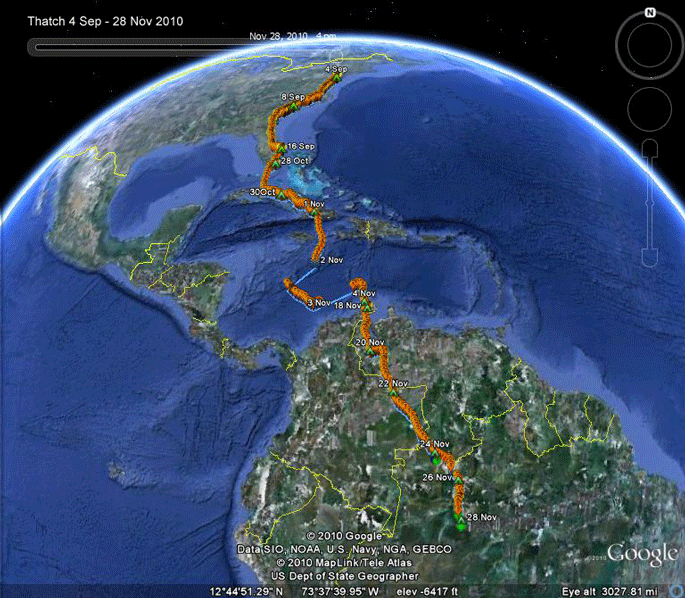 |
Thatch is on a wild ride - 4 Sep-13 Dec. I can't take too many more Caribbean crossings like this one! Way back in early September, Thatch moved down the east coast and seemed to have dropped anchor in North Palm Beach. It looked like this was it for his migration. Had he stopped there, it would have been the third young from Delaware that made a very short migration. Lew stopped in Savannah, GA, and Little Ricky settled down in Miami. But we know better than to think we have these youngsters figured out. 42 days after arriving in North Palm Beach, Thatch resumed his migration and was in Cuba on the 31st. He was moving southeast through Cuba pretty much on a collision course with Tropical Storm Tomas. He made it across the Caribbean in the most nerve-wracking trip I've yet watched. After about 2 weeks on the Gulf of Venezuela, he kicked back into high gear and pushed southeast all the way to the Amazon River over the next 11 days. Teenagers! Scroll down for detailed maps. Jump to the start of migration. Jump to South American travels. |
 |
The first week: 26 July-2 Aug. Thatch is sticking very close to
home. He's only made a couple of trips up to the Bay, and he didn't stay long up
there before coming home. One of the cool things about following these Ospreys is noting interesting landscape features. The lines of pines down in the park I assume are related to the changing shoreline of the Bay. |
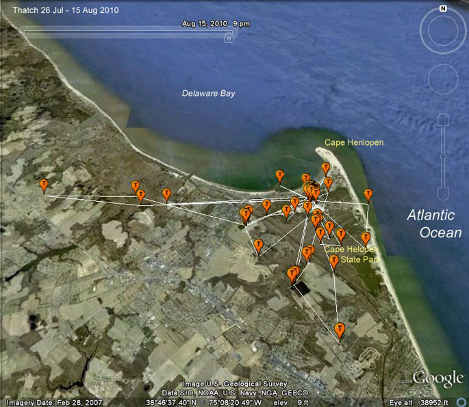 |
26 July-15 Aug. Thatch is exploring a bit more in these first two weeks of August. |
 |
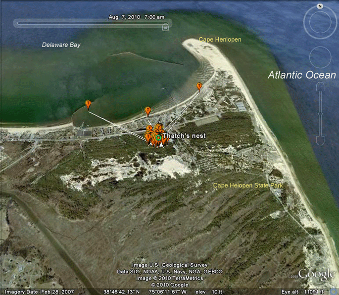
16 Aug-2 Sep 2010. Thatch is expanding his horizons. He's made a couple of trips out over the open Atlantic and has been down to Rehoboth Bay once. He's still pretty much a stay-at-home youngster. His farthest trip from home so far has been about 7 miles (11 km). |
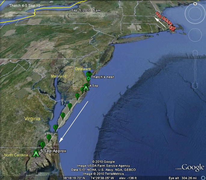 |
4-5 Sep. Thatch is heading south. His probable half-brother
Claws
(the female at this nest is new) showed the same behavior-very little
exploration before heading south. Thatch began his first migration around 2 PM and moved only 36 mi. south. Day 2 of migration covered 150 mi. Meanwhile, up north in Massachusetts, while Thatch starts his first migration, Belle has left Martha's Vineyard and is heading north. |
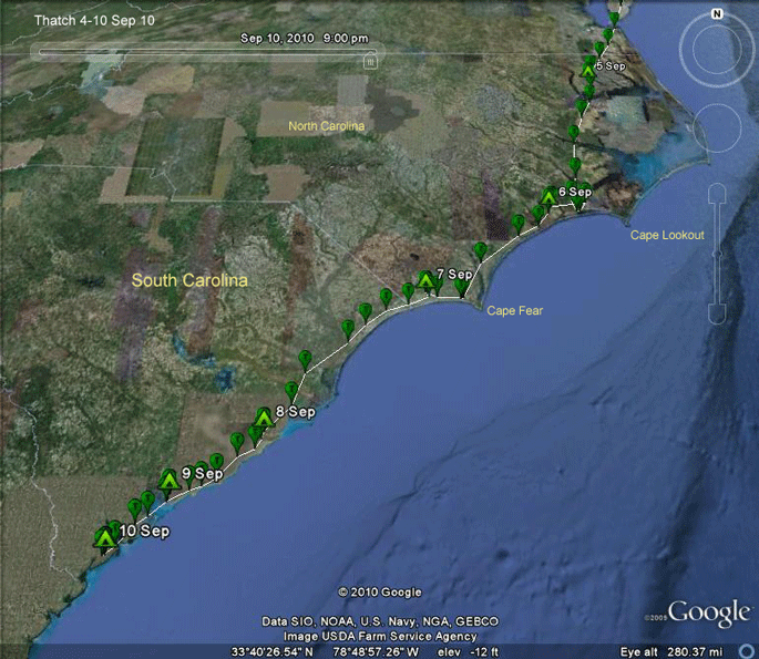 |
5-10 Sep. Thatch is hugging the coast as he
moves south. On the 10th he made it to Hilton Head Island and roosted
0.3 miles from our timeshare down there. Through the 10th, he has traveled about 600 mi (970 km). (Up north in Massachusetts, Belle changed her mind and is back at home.) |
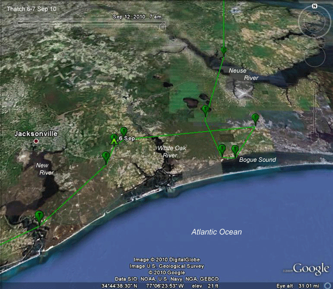 |
6 Sep. Thatch arrived at Bogue Sound on the
North Carolina coast around
3 PM and probably did some fishing. (Each balloon is an hour after the
last, so you can get a feel for how long he was in the area. By around 6
PM he had pretty much settled down for the evening. Around 9 AM he was back on migration, heading southwest. |
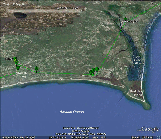 |
7 Sep. Thatch left the New River area around
9 AM and flew through Wilmington, NC, 3 hours later (Walker, did you see
this one?). He stopped after only 4 hours of real migration just west of
Bald Head Island. He probably followed the Cape Fear River down to Bald
Head. Remember that the lines connecting points on these maps don't
necessarily mean that the bird followed that path. Around 4 PM he flew west to the Shallotte River and bedded down for the evening. He started the next leg of his travels around 10 AM. |
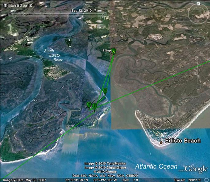 |
9 Sep. Thatch spent the night of the 8th
northeast of Charleston, SC, and arrived in the Edisto Beach area around
3 PM on the 9th. He spent 2 hours in these coastal marshes presumably topping off
the tank and then moved inland a bit to spend the night. He got a relatively late start (11 AM) on the 10th, maybe after a bit more fishing. Heck, If I'd been there, I would have been fishing! |
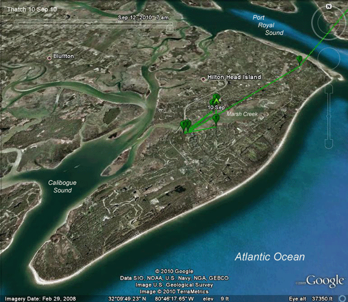 |
10 Sep. Thatch is hitting all the big golf locations down the coast--Kiawa, Isle of Palms, Seabrook Island, and now Hilton Head. He got to the 'heel' of Hilton Head Island (a foot if there ever was one) around 2 PM and then found Marsh Creek, where he spent the rest of the day. |
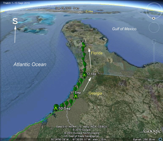 |
10-13 Sep 2010. Here's one of our upside-down maps. We're looking
south over Thatch's shoulder as he heads down the Florida peninsula
towards Cuba. He only spent the night on Hilton Head Island on the 10th. On the 11th he moved a bit further south into Georgia. He probably got some fishing in on Hilton Head, as he didn't leave the island until a bit before 10AM. |
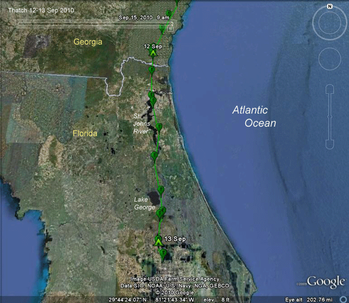 |
12-13 Sep 2010. Looking north again, we see Thatch coming into
Florida and making the obligatory trip down the St. Johns River. If I
were going to watch Ospreys on migration in the fall in Florida, this is
where I'd be. He stopped on the 13th and spent the night near Wekiwa Springs State Park. |
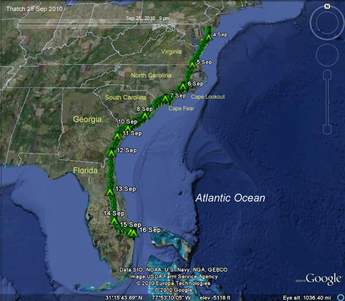 |
4-16 Sep 2010. The whole trip so far. |
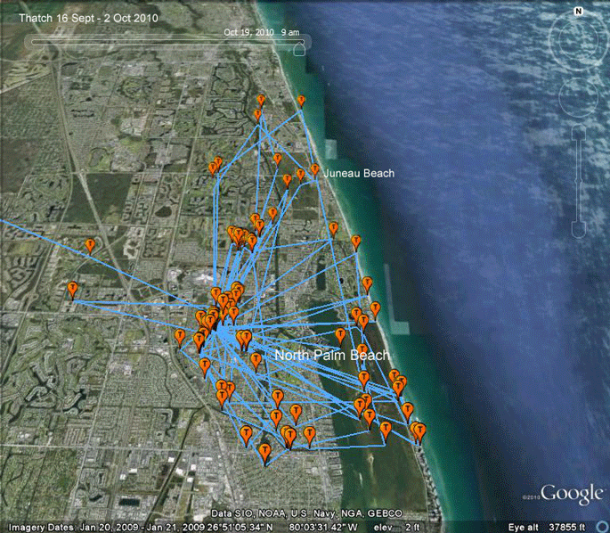 |
17 Sep - 2 Oct 2010. This really looked like he was going to settle down here in North Palm Beach. |
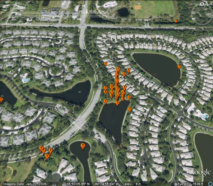 |
17 Sep - 2 Oct 2010. This development in North Palm Beach was headquarters for 42 days. |
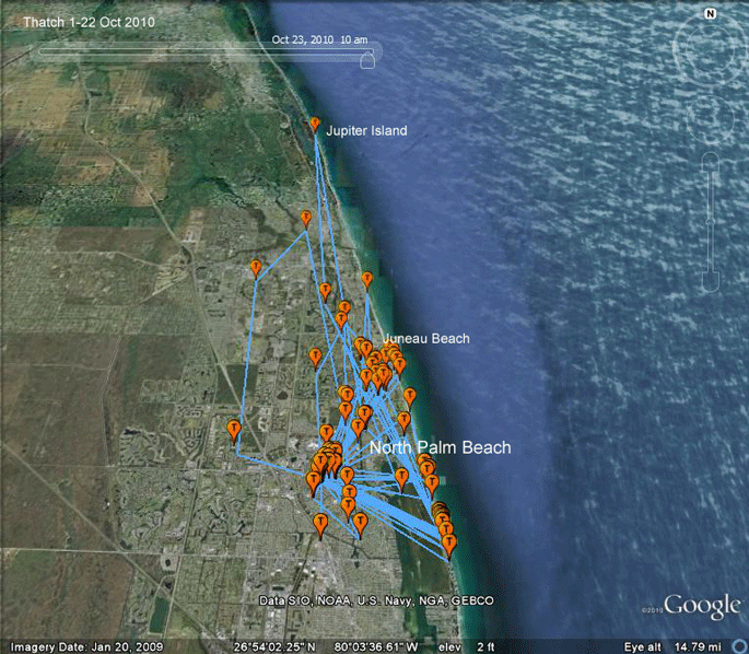 |
1-27 Oct 2010. Thatch was expanding his range north a bit, and then on the 28th..... |
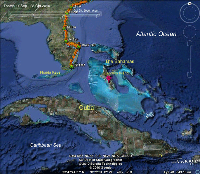 |
28 Oct 2010. .... he took off on migration again! Just when I thought we had everyone tucked into their wintering grounds and didn't have to worry about our birds dodging fish farms and hurricanes in the Caribbean, we've got another one heading into the risk zone. Ugh. |
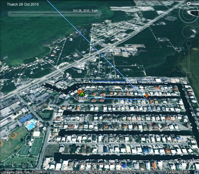 |
28 Oct 2010. Thatch is obviously very used to living in the midst of dense human population centers. This is OK up here, but this total lack of fear of humans is not a good trait south of the Keys. This was his roost spot in Key Largo. |
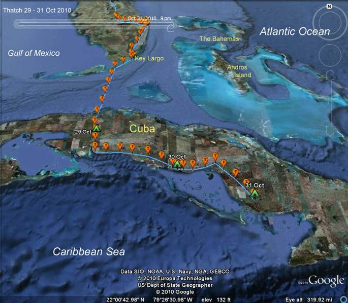 |
28-31 Oct 2010. Thatch has it on cruise control. About 8 hours on
the wing each day. The roost area on the 29th (see below) wasn't at an
obvious fishing spot, so maybe he's doing a bit of hunting before
getting going each day, or he may have just skipped a meal. We know they
can do that after we've seen them fly over the Atlantic for 50 hours
non-stop. The difference between this track and those of adults is another indication that young are just orienting--heading off in a pre-programmed direction with no knowledge of where they're going, as opposed to navigating, where you know where you are and are heading to a specific location. All the adults get to Cuba and turn southeast, flying down the middle of the Island. They know where the D.R. is. Many of the young keep flying south until they hit Cuba's south shore. Then, if the urge to migrate is still working, they follow the "stay over land if at all possible" imperative and follow the coast to the eastern tip of Cuba. Then, there's no more land to stay over, so it's over water on to Hispaniola. |
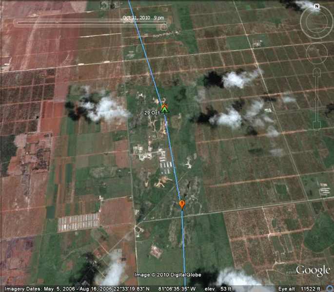 |
29 Oct 2010. Thatch didn't start migrating until 09:00 AM. Hard to see where he might have done any fishing around here, so maybe he was just waiting for thermals to develop. |
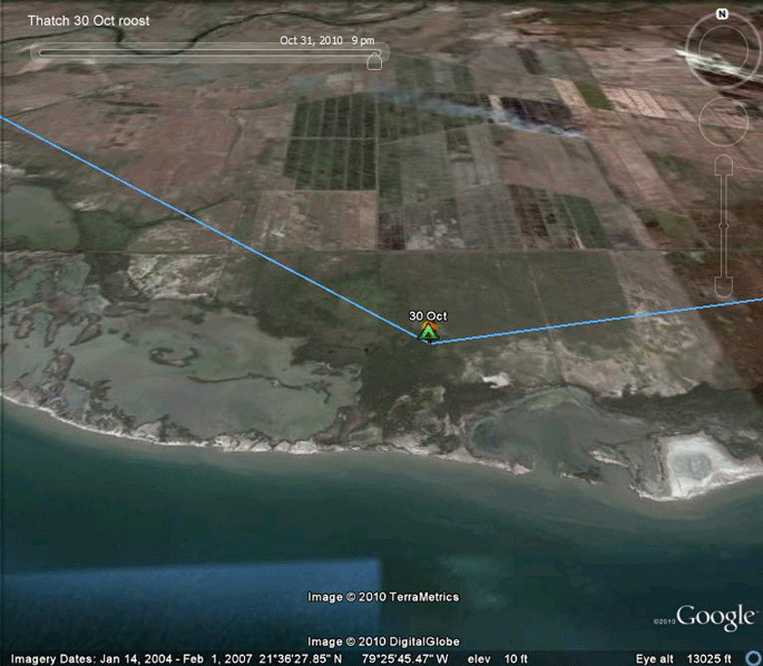 |
30 Oct 2010. Here's a roost that has some promise, right on Cuba's
south coast, with some nice shallow bays to fish in. He got a pretty
early start, just before 8AM, but that would have given him a couple of
hours to fish before moving on. Cuba's resident Osprey expert, Freddy Santana, who counts Ospreys on migration further down the coast (just above Guantanamo Bay), sometimes sees them flying by with a fish in their talons. Packing a lunch, he calls it. |
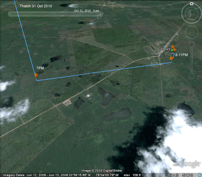 |
31 Oct 2010. Thatch got to this set of small ponds at 7PM and spent an hour in the area before settling down for the night. So he did have a chance for an evening snack before roosting for the night. |
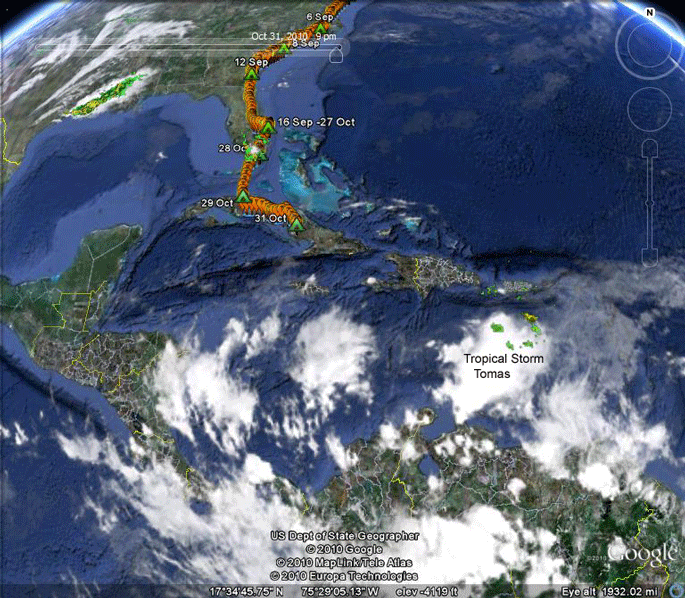 |
30 Oct 2010. Here's what's in store for Thatch. Looks like heading for a wall of bad weather. Yuck. |
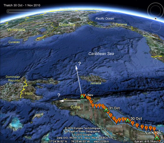 |
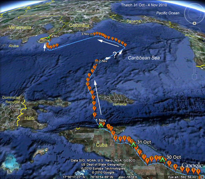
30 Oct-1 Nov 2010. Looking south! Thatch continued hugging Cuba's southern shore as he moved on 1 Nov. He took off at 9 AM and settled down 142 miles further along the coast around 6:30 PM. So what next? Will he continue along the coast, as most young Ospreys do? Or will he head south? The deciding factor is likely to be the wind. One thing we do know is that there is a lot of weather in Thatch's future. |
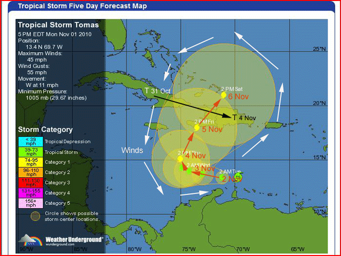 |
1-4 Nov 2010. Predictions. Tropical Storm Tomas was a hurricane a few days ago, but ran into some strong high altitude winds that demoted it to tropical storm strength. Those same winds are expected to push the storm back to the east, right over Haiti (really bad news for all the Haitians living in tent cities after the earthquake). As it moves over the Caribbean it is likely to pump itself back up to hurricane strength. If Thatch keeps going, he should get to the D.R. a day before the storm. Depending on his progress and that of the storm, he should be feeling strong headwinds at some point and may just hunker down. I hope he does that before he gets to the Osprey shooting grounds also known as the D.R. Alternatively, he might run into strong winds from the north and use those to give him a boost down towards South America. Sure wish he was still in North Palm Beach. I need some valium. |
 |
1 Nov 2010. This is pretty much what's waiting for Thatch if he goes south. The Doppler radar image is actually from the 3rd, but not much changed during this time. Getting through that wall of wicked weather looks like an impossible task. |
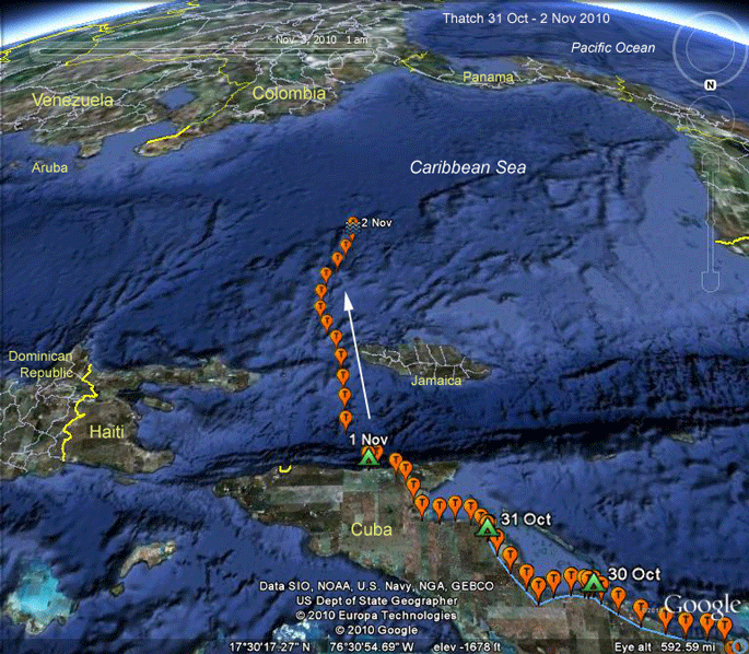 |
1 Nov 2010. Looking south. Oh, well, here we go! Hang on to your hats, it's wet and windy out there over the Caribbean. At this point, the storm was southeast of him, so he had strong winds out of the north, pushing him towards South America (up in this map). |
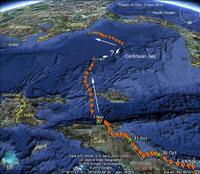 |
3 Nov 2010. Looking south. Thatch is banging around the Caribbean like a ping pong ball in an empty boxcar. We have no idea how he got from the last fix on the 2nd to the first on the 3rd. The last fix on the 3rd was at 9 PM, 36 hours after he left Cuba. |
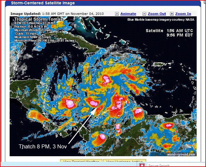 |
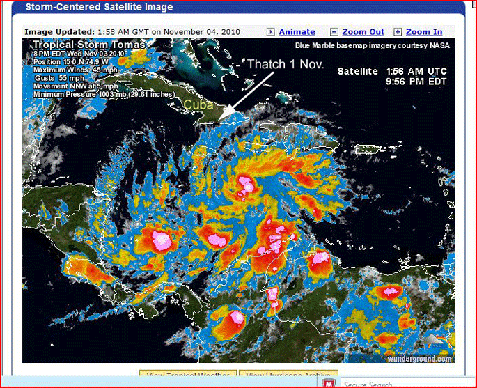
3 Nov 2010. The last map made it look so peaceful over the Caribbean. Here's what he was flying through. The arrow points fairly close to where he was when this Doppler radar weather image was created. At this point, I had written him off as another fatality of a really bad hurricane season. . |
 |
4 Nov 2010. When his GPS turned on again on the 4th, I think he had been swept up in the wake of Tropical Storm Tomas, which was now north of him, and I wrote him off again. Then we got a few more signals showing that at noon on the 4th, 51 hours after leaving Cuba, he was heading south and out of the storm. He made it to land around 6 PM on the 4th, about 57 hours after he left Cuba. During that time, he flew about 1,100 miles (probably quite a bit more as we don't know where exactly he went when his GPS was turned off), so he averaged a pretty healthy 20 mph. The point-to-point distance from his roost in Cuba to his landfall in Venezuela was about 600 miles, so he had 400 miles of detours either around storms, or just being blown around by them. Roy Dennis had a juvenile Osprey get blown out over the Atlantic as it was migrating across the Bay of Biscayne in Spain. That bird was out over the water for 60 hours, as I remember. |
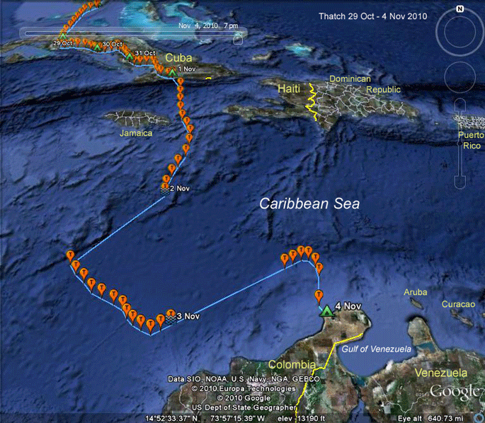 |
4 Nov 2010. In case you were getting tired of standing on your head, looking at the Caribbean upside down.... |
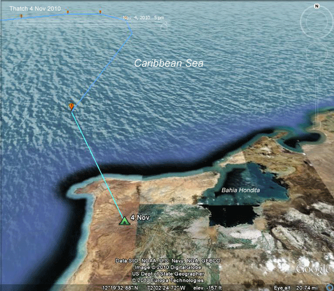 |
4 Nov 2010. He's safely on land, only 7 miles (12 km) from Bahia Hondita, also known as Osprey Nirvana. This is where our first juvenile Osprey, Jaws, spent his 18 months abroad. Thatch has to be exhausted. (I know I am just making the maps!) He's got to fuel up soon, and he's only a few wingbeats from plenty of chow. |
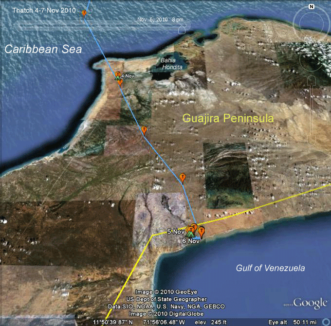 |
4-7 Nov 2010. Around 11 AM on the 5th, after a well deserved rest, he moved 39 miles (62 km) south. He might have left his roost area and done some fishing nearby, but if that were the case, it would mean he returned to the roost area before heading south. Much more likely that he just rested there through the morning and then perhaps caught some thermals and pushed on to the south. At about 2 PM he reached the northern shore of the Gulf of Venezuela and set anchor for a few days. |
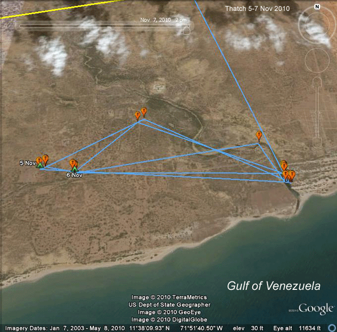 |
4-7 Nov 2010. He found a little slip of a river that, when this image was taken, didn't make it to the Gulf of Venezuela. It must do so in the rainy season, but for when the image was captured, the mouth of the river was shut off by the beach. Maybe Thatch has some fish that are trapped there. The two loops out to the west are interesting. On both the 5th and 6th he was at the two northernmost points at about the same time (4-5 PM) and then wound up roosting on both nights nearby. The distance is only a mile, so he could have been moving around a lot more than it appears here. This is another good example of the potential to over-interpret the lines connecting hourly fixes. He could have flown 10 miles off in any direction and then back to the next location on the map and we wouldn't know it. So why roost away from the little river he's been fishing? Maybe there's some higher ground over there, or something he can perch on to have a view. As we saw when Jaws was on the Guajira Peninsula back in '04-06, this is a remarkably arid environment. Because it is near sea level, moist air coming off the Caribbean won't drop it's water until it is forced up by the coastal mountain range. |
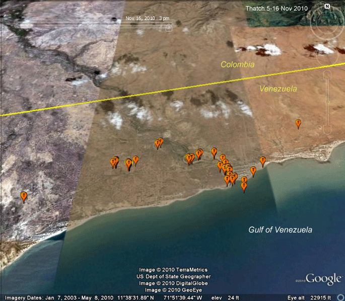 |
4-16 Nov 2010. Thatch is really focused on this one little stretch of river. This isn't surprising, given that there doesn't seem to be any water, other than the Gulf of Venezuela for miles in any direction. He has made a couple of forays out away from his bivouac and he's been out over the Gulf a bit, but he keeps returning to his favorite spot. I do expect that he'll move again. |
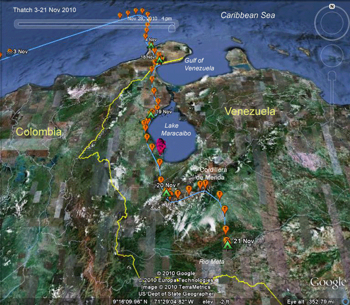 |
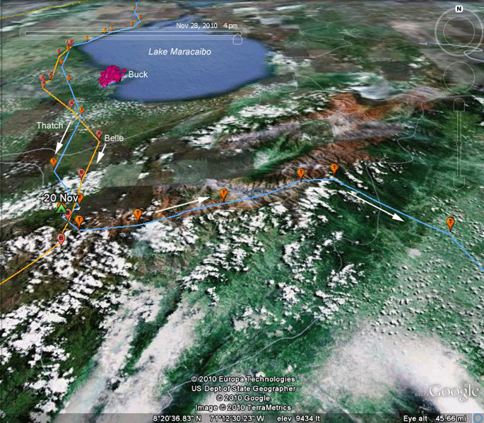
18-21 Nov 2010. Thatch is back in full migration mode, following closely Belle's path through this same area about 10 days before. On the 20th he climbed up out of the Tachira Depression up the northern slope of the Cordillera de Merida and into its central valley. The purple markers are Buck's winter location. Buck is a youngster from '09, due to head north next spring. |
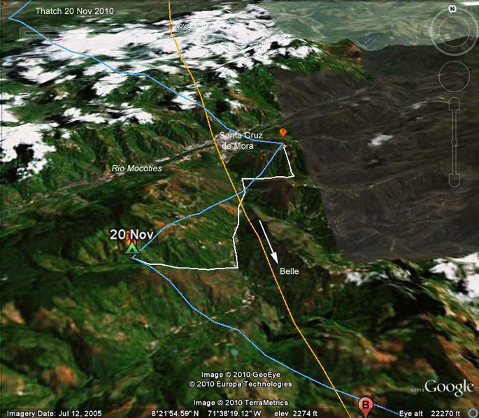 |
20 Nov 2010. Here's Thatch's roost on the 20th, just above Santa Cruz de Mora, in the Cordillera de Merida. Belle (orange track) flew through this same valley on the 10th. The blue line is the "connect the dots" track, linking sequential hourly fixes. When our birds are crossing open water, these tracks will pretty accurately reflect the path the bird took. In this case, however, the two points here are only 3 miles (and 1 hour) apart, so Thatch clearly did something during that hour. I dropped in a theoretical path for him (the while line), which assumes that he dropped down into the river valley and probably did some fishing, working up these valleys. |
 |
21 Nov 2010. He's not taking the easy way here. Maybe it's some sort of macho thing, but for whatever reason, rather then just heading south and getting out of the mountains, he went east following the mountain ridge for about 4 hours, before finally heading down into the lowlands east of the Cordillera. |
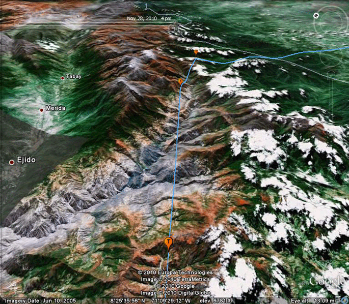 |
21 Nov 2010. Looking east! Thatch picked his way through 48 miles (78 km) of the eastern mountains before turning south into the lowlands. Once again, it's worth noting that he didn't necessarily follow the blue track here, although the way his locations line up so neatly, he probably got up high and flew pretty much on that course. |
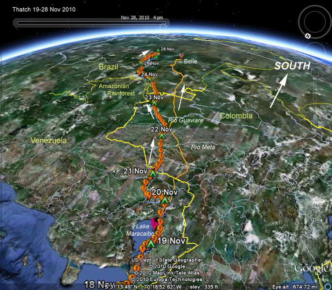 |
19-28 Nov 2010. Looking south! Thatch and Belle (the orange track) took pretty much parallel routes down to the Amazon in Brazil. Belle was about 10 days ahead of Thatch. |
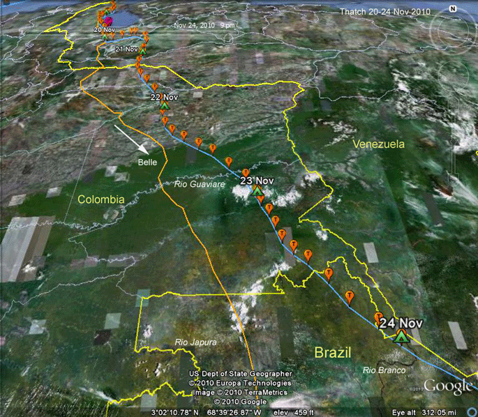 |
21-24 Nov 2010. (Looking north again) The migration switch is in the on position and the throttle is cranked up! Thatch entered the airspace of the Amazon Basin around mid-day on the 23rd. A day later he crossed the Brazilian border and roosted near the Rio Branco, one of the tributaries of the Rio Negro, which in turn flows into the Amazon at Manaus. |
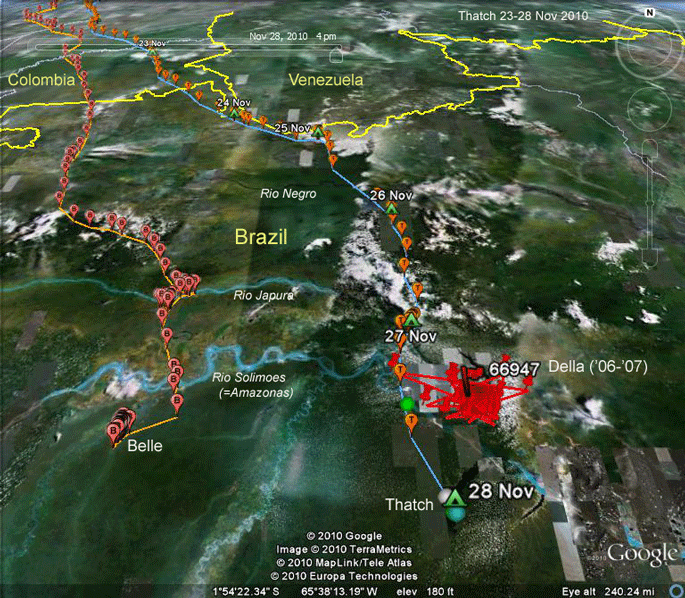 |
23-28 Nov 2010. Thatch continues to push south. He's now south of the Solimoes (more on this below), and south of Belle's current spot. He has settled (at least for the night) at a large lake (Lago Caiambe) at the mouth of the Rio Tefe. The red cluster of points is where our '06 Delaware young, rather unimaginatively named (by me) Della, spent a year and a half. We lost her signal in Dec. '07, just a few months before she would have headed north for the first time. |
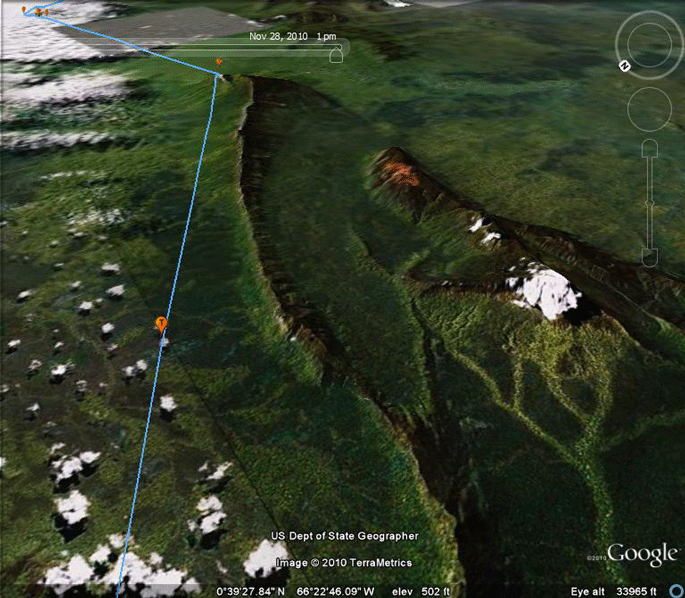 |
25 Nov 2010. Just doing a bit of Google Earth sight seeing here. Thatch flew through this interesting area about mid-day on the 25th. Scattered around the northern Amazon are occasional random mountains. These are just 15 miles southwest of Pico de Neblina (Fog Peak), Brazil's highest mountain. It reaches 2,994 m (9,823 ft) and is only 687 m (2,254 ft) from the Venezuelan border. Because this area is so inaccessible, it was only discovered (from the Brazilian side) sometime in the 1950s. The details are vague. |
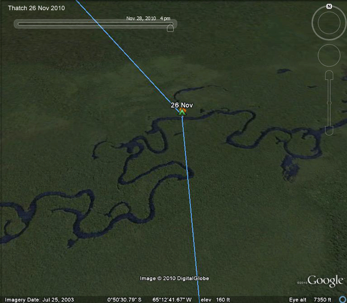 |
26 Nov 2010. Roost site on some small tributary of the Rio Negro in northern Brazil. |
 |
27 Nov 2010. Roost site at the confluence of the Japura and Solimoes Rivers. A geographic aside: In Brazil, the Amazon above the confluence of the Rio Negro and Amazon is called the Solimoes. This is because when explorers were coming up the Amazon and got to the Rio Negro, they thought the Rio Negro was the main river (the Amazon) and that the Amazon was a tributary, so they called this tributary (which is really the main stem of the river) the "Solimoes." Only later did they discover that the Negro is the tributary. Once they figured that out, they gave the Rio Negro its curretn name and left the "Solimoes" moniker on the Amazonas. Going upriver on the Solimoes, when you get to Peru, it's called the Amazonas again! This can be very confusing for a young ornithologist, heading to the Amazon for the first time, looking up the ranges of rainforest birds. The ranges of many rainforest birds go from one river to another. In my atlas, I could find all the rivers except this darned "Solimoes." It took forever to figure it out. |
 |
28 Nov 2010. Our last satellite fix was before the last upload from the transmitter on the 28th. The colored dots are satellite-determined locations, rather than the GPS points we usually use. Thatch has arrived at a large lake formed by the Rio Tefe as it meets the Solimoes. Will this be the spot? Certainly looks like a good area to spend 18 months. We'll see! This is as far south as any of our birds have been in the Brazilian Amazon. Way back in 2001 we had an adult female from Charlotte go further south in the Peruvian Amazon. The Osprey-ometer now reads 4,198 miles (6,756 km). He left home 86 days ago. Of these 86 days, he's been actually migrating 34 days. On his migration days, he has covered an average of 123 miles (199 km)/day, which is just a wee bit (that's a very technical statistical term) below the average for all our birds. |
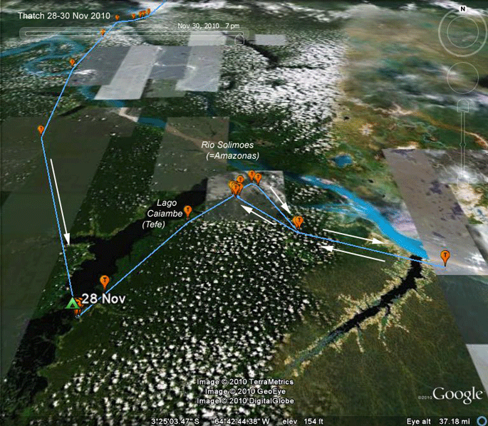 |
28-30 Nov 2010. Looks like Thatch likes the look of Lake Caiambe. He did make a quick 55 mile (89 km) exploratory trip down river, but returned the same day. Another bit of random Amazonian geography--the lake was formed because the Solimoes (Amazon) River deposited so much sediment at the mouth of the Tefe River, that it effectively dammed the river. The Tefe still flows out into the Solimoes, but it does so through a fairly narrow channel. |
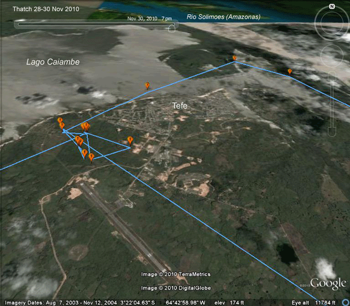 |
28-30 Nov 2010. Guess we really didn't expect Thatch to find some quiet, remote, safe corner of the Amazon in which to spend the next 18 months. Trust this nerve-wracking Osprey to settle down right next to a small city at the end of the airport runway! Yikes. |
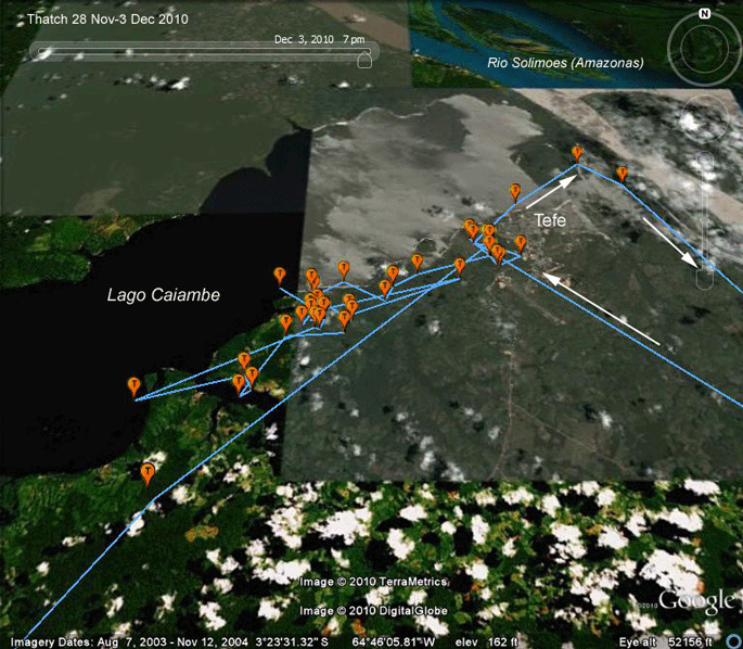 |
28 Nov-3 Dec 2010. Well, at least he's not camped out at the end of the Tefe airport runway anymore, and he's a bit further from town. Breathing a little easier now. |
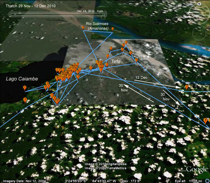 |
29 Nov-12 Dec 2010. Thatch definitely moved away from the end of the Tefe Airport runway (much to our relief) and spent most of the next two weeks on the south shore of Lake Caimbe. On the 12th he decided to do some exploring and moved east to the next big lake on the south bank of the Amazon. |
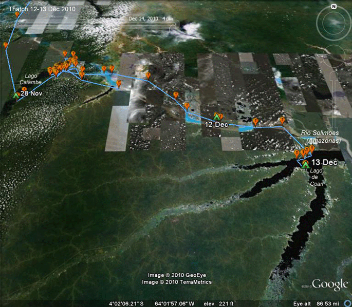 |
12-13 Dec 2010. Looks like Thatch got tired of the lake where he'd been fishing for a couple of weeks and moseyed down the Amazon, or Solimoes, as it's known by Brazilians upstream of the confluence with the Rio Negro. He flew about 110 miles (180 km) down the Amazon in two days. |
 |
13 Dec 2010. Thatch arrived around 11 AM at Lake (Lago) Coari, another lake created by a natural levee formed by the Amazon river. Over the next 4 hours he moved 6 miles(9.5 km) down the shoreline, probably fishing as he went. He then flew across the lake and settled down for the duration of the day. Will he settle here, go back to Lago Caiambe, or move on? Stay tuned! |
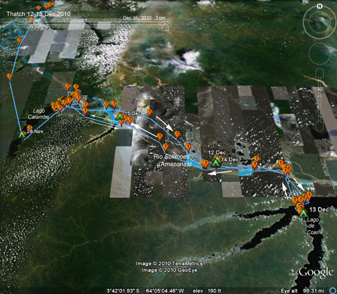 |
12-15 Dec 2010. Well, that didn't last long. The electrons had hardly had time to settle on the last maps I made when I discovered that Thatch was on his way back to Tefe and Lago Caiambe. This suggests that Thatch will call Lago Caiambe home for the next 18 months or so. Some young arrive at a spot and settle there for the duration, but many settle down and then make "road trips" to explore the surrounding terrain in search of greener grass, or, more specifically, more fish. Too early to say, of course. He may find a better spot, but apparently Lago de Coari did not impress. Not that he gave it much of a chance. |
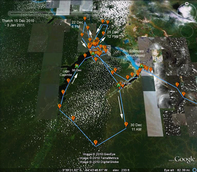 |
15 Dec 2010-3 Jan 2011. Thatch is still exploring a bit, but is certainly focused in on the Tefe area at the north end of Lago Caiambe. |
Birds of Prey page -- Osprey main page -- Migration page -- Home Page