Conomo
2008
maps for Conomo
'09 maps for:
Bea
--
Buck -- Caley --
Claws --
Conomo --
Hix --
Hudson 09 -- Isabel --
Katy -- L.R. --
Moffet --
Mr. Hannah --
Ozzie --
Penelope
--
Rafael
2010 maps for: Belle
-- Buck --
Gunny --
Hudson --
Mr. Hannah --
Neale --
North Fork Bob
--
Penelope --
Sanford
-- Sr. Bones --
Thatch
2011 maps:
Belle --
Buck --
Henrietta --
Katbird
-- North Fork Bob --
Pemi --
Saco --
Sanford --
Sr. Bones --
Snowy --
Thatch -- Tucker
2012 maps: Art --
Belle --
Bridger --
Chip --
Cutch --
Jill -- North Fork Bob --
Rammie --
Snowy --
Sr. Bones -- Thatch
2013 maps: Art --
Belle --
Bridger --
North Fork Bob --
Rammie --
Snowy --
Sr. Bones
Osprey
main page --
Migration
page --
Migration09 --
Migration10 --
Migration 11 --
Migration 12 --
Migration 13 -- Home
Page
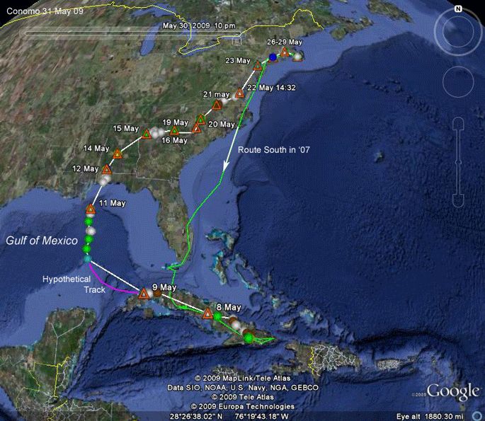 |
30 May 09.
Conomo is home again, safe and sound!
He left the Cuban reservoir that had been his base of operations for 18 months on the 8th of May. He missed the sign that says "Turn Right for Florida" about midway through Cuba and overshot the easy passage to the Keys. As a result, he wound up crossing over 600 miles of the Gulf of Mexico--instead of 90 miles to the keys. But looking at his route south, depicted in green on this map, 600 miles of open water is nothing for an explorer of his stamina. He took care of over 500 miles of the Atlantic between North Carolina's Outer Banks and Florida on his way south. Remarkably, once he made landfall in Alabama he somehow knew that he was too far west and corrected his route to get back to New England--this is true navigation. The whole trip was 2,581 mi (4,516 km) in 23 days. Had he gone through Florida the trip would have been 500 miles shorter! He arrived on 30 May, 23 days after he started north. A word of explanation on the colored points on this map--Conomo is our last bird carrying a transmitter that does not use GPS technology. His transmitter simply sends out a radio signal. A computer program estimates where the signal came from. The estimates are more or less reliable. The color coding tells us how accurate the computer thinks the fixes are. Green and blue are good. White is better than yellow, which is better than brown. The pink line leaving Cuba is the route he probably took. His transmitter wasn't on between leaving Cuba a bit west of Havana and our first location for him out over the Gulf. At one point on this trip, he was about 30 miles from "Map Central" here in Charlotte! Below are maps in chronological order beginning with January '09. |
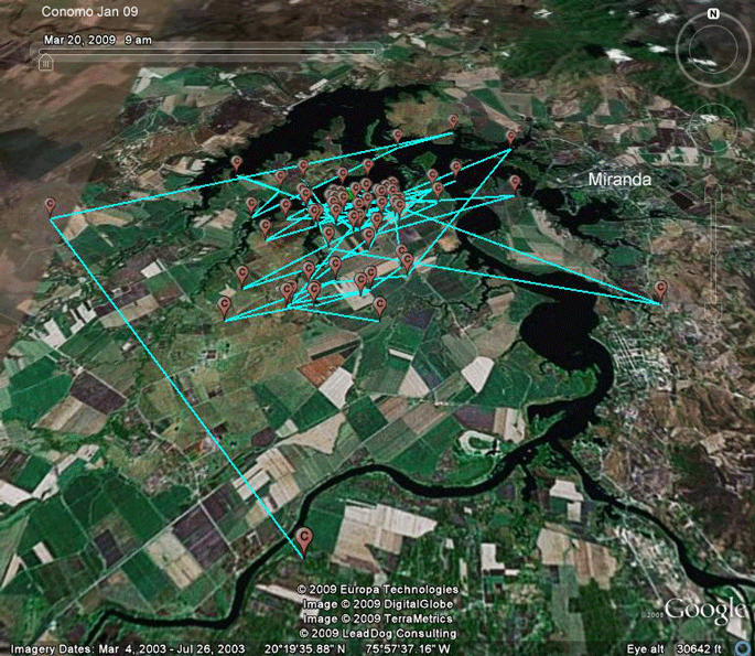 |
Jan-Apr 09. These points (from Jan 09), at the southern edge of a reservoir about 50 mi (80 km) west of Guantanamo, are representative of his winter range since his arrival here in Nov. 07. On that first migration south, he made it to the eastern end of Cuba but then, rather than continuing on to Hispaniola as do most Ospreys, he backtracked to this spot and set anchor. He had seen it on his way east a few days before opting out of the crossing to Hispaniola. |
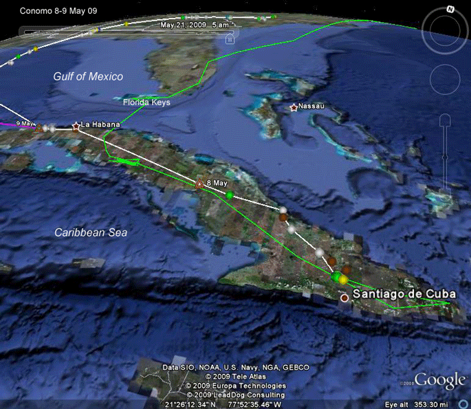 |
8-9 May 09.
At
10:39 on the 8th of May he was 75 miles into his first migration home.
Given an average speed of about 25 mph, he probably left his reservoir
north of Santiago between 07:00 and 08:00 local time. We don't know exactly where he spent the night on the 8th, because his transmitter shut down for the day in the afternoon. We do know that he made it past Havana and spent the night of the 9th near the coast, having knocked off about 525 mi. (840 km) in two days. We also don't know exactly what route he took between the marker for 8 May and his roost on the 9th, but it was surely pretty close to the route he took on the way south (the green line). So, he could have recognized some landmarks when it was time to go north to FL. But it was 18 months ago that he passed through this area, so I can't blame him for missing the turn! |
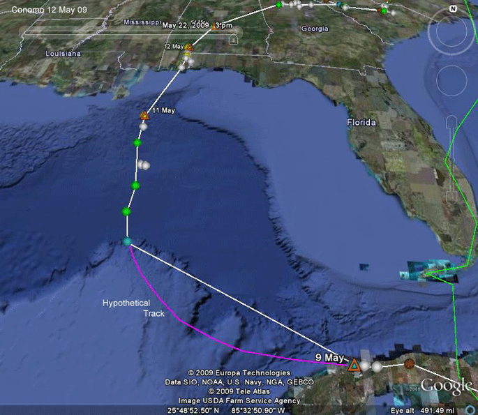 |
9-12 May 09.
Conomo's transmitter was not active
when he left Cuba's northwestern shore. When it came on he was heading
pretty much due north. He surely didn't make a right turn at that first
location out over the Gulf, but
rather must have made a more gradual course correction somewhere between the two points. I've
sketched in a hypothetical track. (This is another good example of why
we should be careful interpreting the lines between satellite
locations.) The 3 green locations out over the Gulf are fairly accurate, so I calculated his speed over that 3-hour stretch to be 26 mph, which is pretty typical. Using that speed, we can estimate that he left Cuba around11:00 on the 10th and landed in Alabama (a new state for our birds) at 16:00 on the 11th, about 29 hours later. |
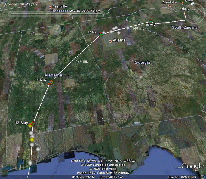 |
12-16 May 09.
After 29 hours on the wing over the
Gulf of Mexico, Conomo rested at the coast and then on the 12th flew
another 75 miles inland, where he spent that night and the 13th near
Chrysler, AL. On the 14th and 15th he crossed the rest of Alabama and
settled down at the Allatoona Reservoir NW of Atlanta, GA. He spent the
night of the 16th near Greenwood, SC. The truly remarkable thing here is that he somehow knew, after making landfall in Alabama, that he had to go northeast to get home. He is 500 miles west of anywhere he's ever been, so landmarks can't help. He can use the sun and magnetic fields to know where north is, but there is no east-west information available to him that we know about. On his first trip south he was not navigating--he had no destination in mind. He was just heading south until something told him to stop and settle down. Now, he is truly navigating. In order to navigate you need to know where you are relative to your destination so that you can correct your course. We have no clue what could be telling him that he had gone too far west and had to go northeast to get home. The earth's magnetic field varies from place to place and birds do learn, or even in some cases inherently recognize certain "signature" magnetic fields, but this bird is way off course, so he can't recognize this spot, magnetically speaking, and he certainly isn't genetically aware of where he is. The more one thinks about this, the more incredible it becomes. |
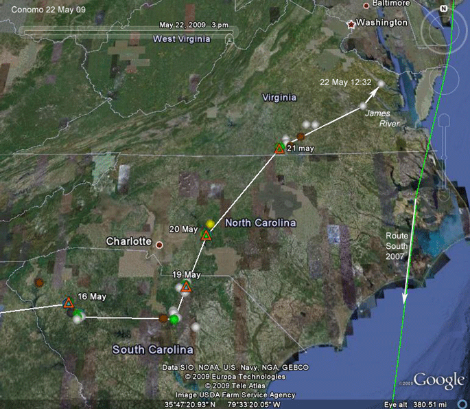 |
16-22 May 09.
On the 16-18th, he seemed to find good
fishing at Lake Greenwood in western SC and lingered there. On the 19th he flew across
the state, finally turning north a bit (after a stop at Hermitage Mill
Pond in Camden) before roosting near Jefferson, SC. On the 20th he flew into NC and spent the night on Lake Tillery. Astute observers will notice a detour around Charlotte--guess he didn't want to stop at my place for a visit. Next stop on our reservoir-hopping trip through the southeast was the John H. Kerr reservoir on the NC/VA line. We've had other birds spend time here. Our last signal from him on the 22nd on the Rappahannock River, south of Washington, DC, just west of Chesapeake Bay. |
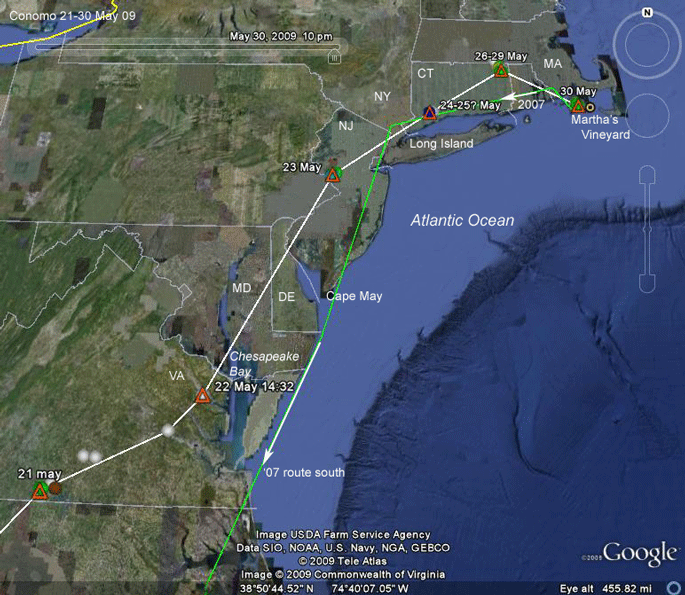 |
22-30 May 09.
Our last point on the 22nd was not a
roost--he was probably still heading northeast. We don't know where he
spent the night of the 22nd, but he roosted on the 23rd in western NJ,
in Rocktown, about 5 mi. east of the Delaware River. On the 24th he moved 104 mi. (167 km) northeast to Trumbull, CT. This is the first time since the middle of Cuba that Conomo has been on ground that he's seen before. Probably on the 26th, he moved another 80 mi (128 km) northeast to Windham County. This is particularly interesting. He has been in SW Connecticut before, so he might theoretically have recognized some landmarks and retraced his route more directly back to Martha's Vineyard. Instead, he continued on the heading that got him to Trumbull. This took him to NE Connecticut, which seems to be a favorite hang-out for Martha's Vineyard Ospreys (as detailed in the next map). Conomo sat out some bad weather for three days in Windham County before making the last, 75 mi. (121 km), leg of his trip home on the 30th. The trip north took 23 days--16 moving and 7 waiting. On travel days, he averaged 161 mi (260 km)/day. He logged 2,581 mi (4,516 km) on the Ospreyometer in this first trip north. Can't wait to see what he does on the next trip! |
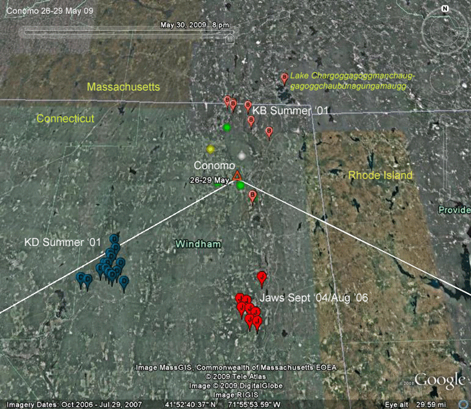 |
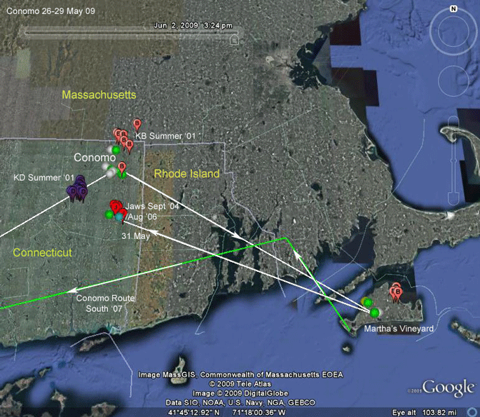
26-29 May 09.
This corner of Connecticut has seen a lot of action
from our tagged Ospreys. In 2001, after their nests failed females KB
and KD began commuting between their nesting territories and locations
that they appeared to be familiar with. When KD's nest failed she flew
straight to this location and then started going back and forth, making
five roundtrips during June and July. KB arrived at Lake Chabunagunagmog
(the full version is on the map) as Lake Webster used to be known, via a
slightly more circuitous route passing through central MA. Once she got
to NE CT, she started commuting back and forth. The most accurate locations (LC2 and 3) from those summers are indicated on the map. Jaws, a fledgling tagged in '04, settled down in eastern CT for a month before beginning his migration to Colombia. After his first summer back on the Vineyard a year and a half later, Jaws flew straight to this same area to "stage" for his second trip south, suggesting that KD and KB had also found good fresh-water fishing holes in NE Connecticut on their first trips off the Island as juveniles, or maybe on their first return trip, as did Conomo, and had these spots in their memory banks, and headed to them when fishing was not so good on the Vineyard. I put this map in the top 5 most interesting since the project began. |
 |
26 May-2 June 09.
Rather remarkably, Conomo only spent two nights on
the Vineyard before heading back to eastern CT. On this return trip, he
found the site that Jaws used as a staging area for two southbound
migrations. As in the previous map, summer areas for females KB and KD are indicated, as is KB's 2001 nesting area at Felix Neck Wildlife Sanctuary. |
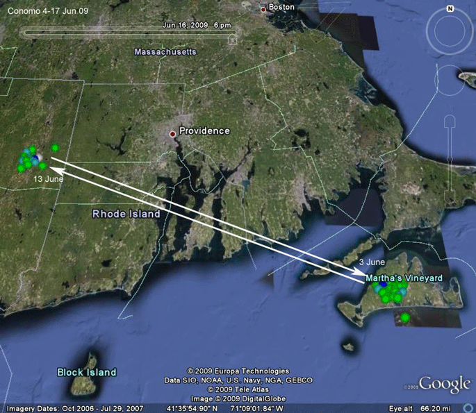 |
3-17 Jun 09. Our peregrinating Osprey continues to suffer from indecision. After only a couple of days in Connecticut, he flew back to the Vineyard sometime on the 3rd of June. He spent a whole 10 days there before high-tailing it back to the Quinnibaug River. The trip is only 68 mi (109 km), which is about a 2.5 hour fight--nothing for a teenaged Osprey with not much on his mind! |
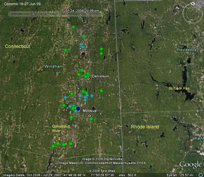 |
17-27 Jun 09. We have lost our signal from Conomo. After his last short visit to the Vineyard, he settled down for a couple of weeks in western Connecticut foraging mostly along the Quinebaug River. On this one, I'm holding out hope that it's just a bad transmitter (PTT). This particular PTT has been around. It's the transmitter we used on Moshup back in '06. We got it back after Moshup was shot in the Dominican Republic. The PPT was refurbished and deployed on Conomo two years ago. I won't be surprised if someone spots Conomo flying around the Vineyard this summer. |
Birds of Prey page -- Osprey main page -- Migration page -- Home Page