Henrietta - 2011
'09 maps for:
Bea
--
Buck -- Caley --
Claws --
Conomo --
Hix --
Hudson 09 -- Isabel --
Katy -- L.R. --
Moffet --
Mr. Hannah --
Ozzie --
Penelope
--
Rafael
2010 maps for: Belle
-- Buck --
Gunny --
Hudson --
Mr. Hannah --
Neale --
North Fork Bob
--
Penelope --
Sanford
-- Sr. Bones --
Thatch
2011 maps:
Belle --
Buck --
Henrietta --
Katbird
-- North Fork Bob --
Pemi --
Saco --
Sanford --
Sr. Bones --
Snowy --
Thatch -- Tucker
2012 maps: Art --
Belle --
Bridger --
Chip --
Cutch --
Jill -- North Fork Bob --
Rammie --
Snowy --
Sr. Bones -- Thatch
2013 maps: Art --
Belle --
Bridger --
North Fork Bob --
Rammie --
Snowy --
Sr. Bones
Osprey
main page --
Migration
page --
Migration09 --
Migration10 --
Migration 11 --
Migration 12 --
Migration 13 -- Home
Page
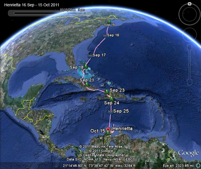 |
616 Sept-15 Oct 2011: Henrietta was our
first bird to start migration this year. She
left Martha's Vineyard around 6 AM on the 16th.
15 hours later she was 464 miles off shore,
averaging over 30 mph. She then probably lost
her tailwind, as her speed dropped over the rest
of the crossing. She made landfall about 43
hours after taking off, having covered about
1097 miles. She cruised right through the Bahamas, Cuba, and Hispaniola, and was safe and sound in Colombia on the 26th, just 11 days after leaving home. |
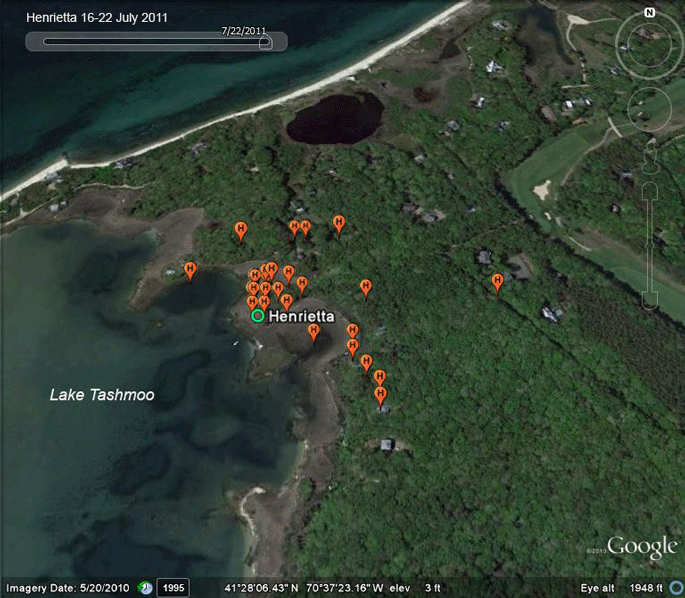 |
16-22 July 2011: Henrietta has been making a few short flights around her front yard. |
 |
27 July-5 Aug 2011: Henrietta is beginning
to explore her world. James Pond is what we like
to call the baby pool. Lots of our young birds
wind up over there as they're beginning to learn
to hunt. And, she made her first trip "off-island." For native humans, this is usually a trip to Costco or Trader Joe's. For our Ospreys, it's a fishing expedition to Naushon Island in the Elizabeth Island chain, or a junket to Cape Cod (see the next map). |
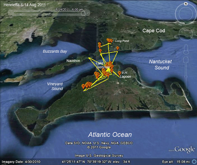 |
6-14 Aug 2011: Henrietta discovered Long Pond north of Falmouth. We've had other young Ospreys from Henrietta's nest find this same pone. |
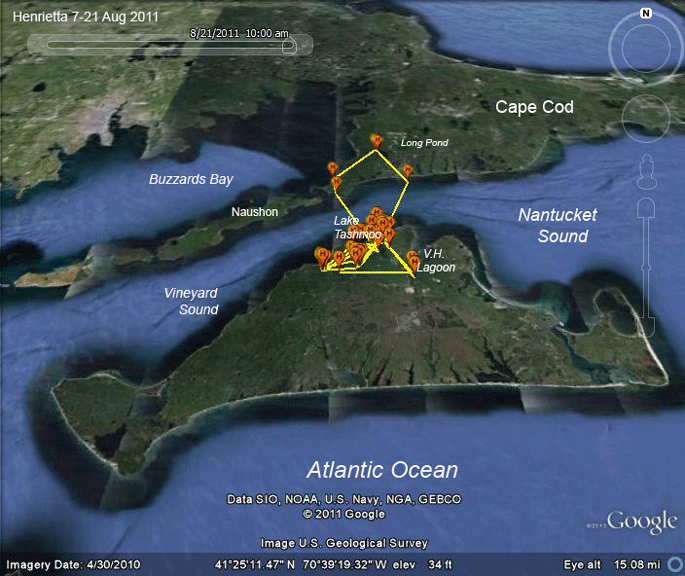 |
15-21 Aug 2011: One road-trip to the Cape. |
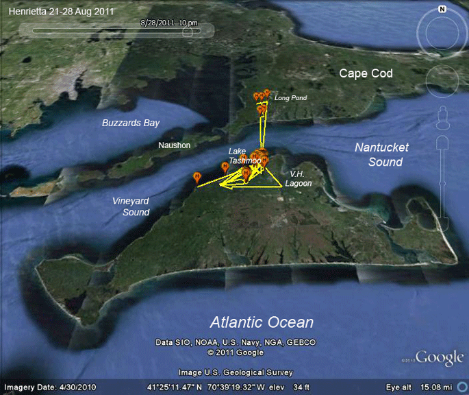 |
21-28 Aug 2011: Henrietta made one trip to the Cape to go back to Long Pond. |
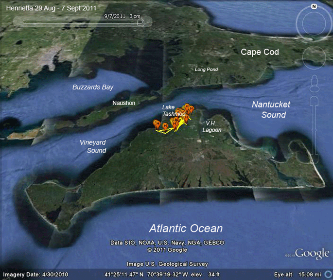 |
29 Aug-7 Sept 2011: Henrietta hunkered down during the nasty weather caused by the remnants of hurricanes Irene and Lee. |
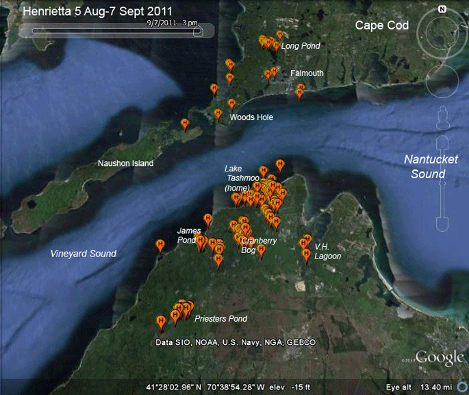 |
6 Aug-7 Sept 2011: Henrietta's locations for a month post-fledging. The Cranberry Bog is just above Duarte's Pond. It probably has a local name, but that's what it's called on the Topo maps. |
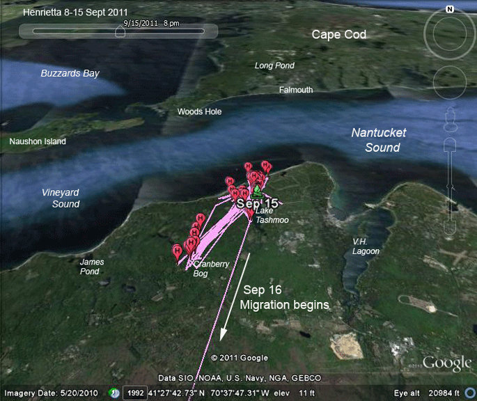 |
8-15 Sept 2011: Henrietta stayed close to home, bouncing back and forth between Lake Tashmoo and her favorite fishing spot a few miles away. She took off bright and early on the 16th, leaving the south shore of the Vineyard behind around 6 AM. |
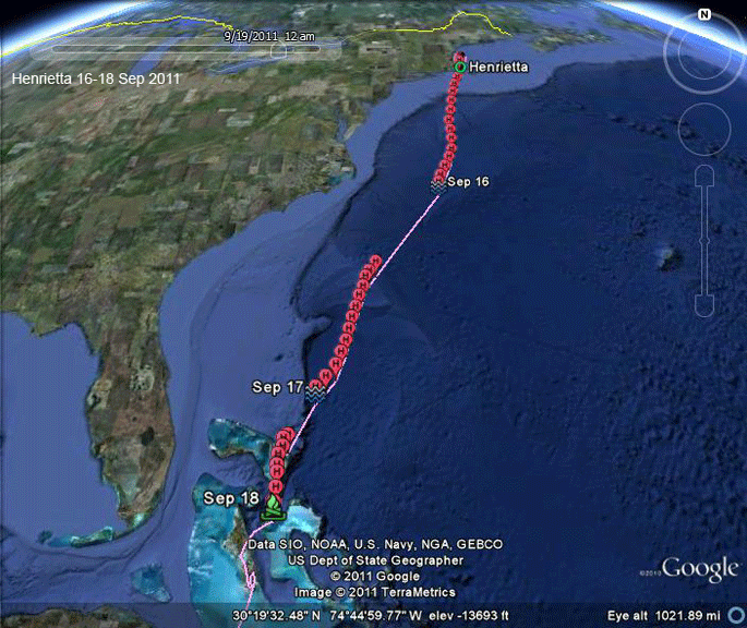 |
16-18 Sept 2011: Henrietta took care of this corner of the Atlantic in about 43 hours, averaging a healthy 26 mph over the non-stop trip. |
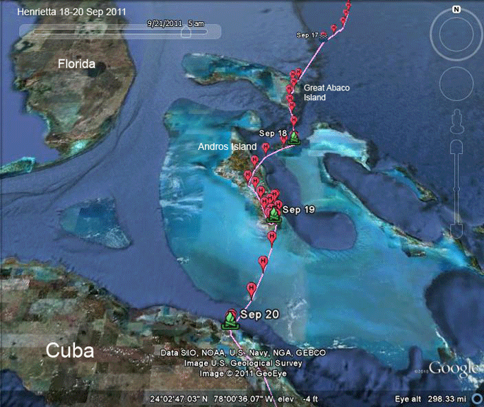 |
18-20 Sept 2011: Henrietta arrived at Great
Abaco Island around 1 AM on the 18th. She didn't
linger long to rest. She spent the night of the
18th on tiny Rose Island just east of Nassau. The next day she hopped over to South Andros Island, where our adult male, Sanford, from the Westport River spent last winter. She left Andros around 3:30 PM on the 20th and then settled down on Cuba's north shore for the evening. |
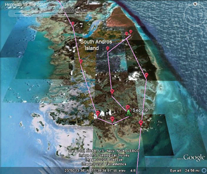 |
19 Sept 2011: Henrietta probably spent the day fishing on South Andros. |
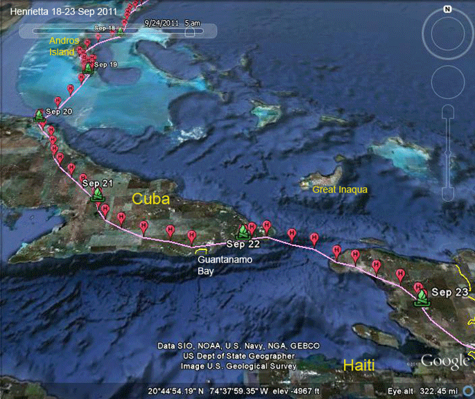 |
20-23 Sept 2011: Henrietta took just a
couple of days to cover the eastern part of
Cuba. She may have been counted by our colleague
Freddy Santana, who maintains a hawk count at
Gran Piedra, just west of Guantanamo Bay. She left Cuba just after 1 PM on the 23rd, and settled down to roost in northern Haiti that night. At this point she had covered 1,892 miles in 8 days, averaging 234 miles/day. |
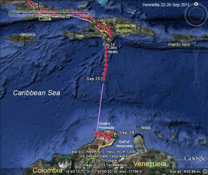 |
23-26 Sept 2011: No moss growing on this
stone! She apparently had clear sailing across
the Caribbean and made it in about the shortest
distance possible. She left Cabo Beato in the D.R. around 9 AM. 9 hours later she was 187 miles (300 km) out over the Caribbean, almost exactly half way across the Caribbean. Assuming she kept up her average speed of about 20 mph, she probably made landfall on Colombia's Guajira Peninsula around 3 AM on the 26th. After catching a few winks and perhaps a fish, she explored the Peninsula roosting that night on its easternmost shore. |
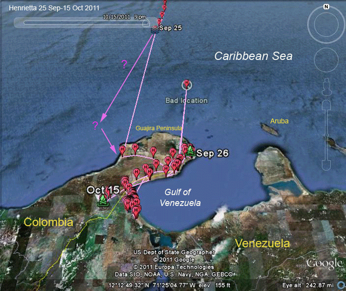 |
26 Sept-15 Oct 2011: Judging from her first
location in Colombia, she may have come in a bit
more from the west than the track connecting her
last point on the 25th to the first on the 26th. This set of data had the first obviously wrong GPS location I've seen. The indicated fix can't be right. She couldn't have gotten up there an back between the two surrounding GPS locations. |
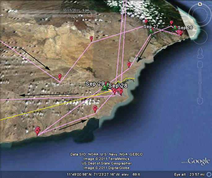 |
20-23 Sept 2011: Henrietta spent a few days exploring the arid Guajira Peninsula. Because it's the northernmost point of land in South America, lots of Ospreys arrive here in the fall and many leave here in the spring. |
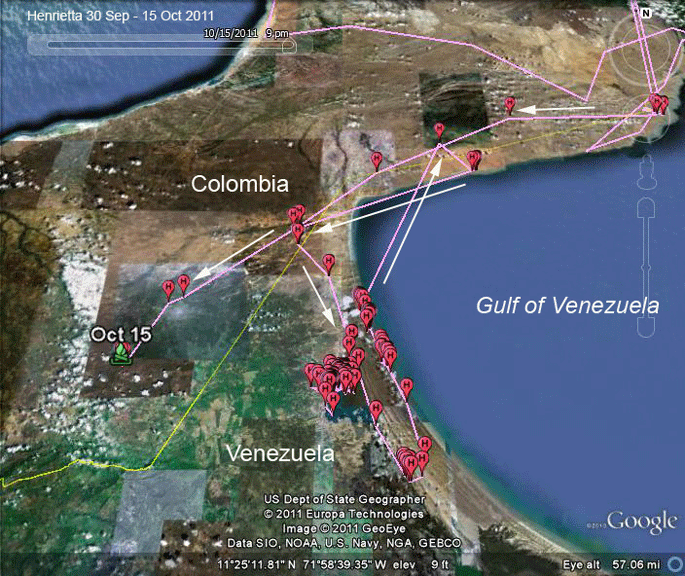 |
29 Sept-15 Oct 2011: Henrietta found the
mangrove wetlands where Buck spent a lot of time
over his first year and a half down in S.A. On the 15th she took off and wandered around a bit before heading on on what looked to be the beginning of an exploratory mission. The signals on the 15th were the last we got from her. This one's a total mystery. She wasn't near any apparent human activity, so we really can't speculate as to what happened. |