North Fork Bob - 2012
'09 maps for:
Bea
--
Buck -- Caley --
Claws --
Conomo --
Hix --
Hudson 09 -- Isabel --
Katy -- L.R. --
Moffet --
Mr. Hannah --
Ozzie --
Penelope
--
Rafael
2010 maps for: Belle
-- Buck --
Gunny --
Hudson --
Mr. Hannah --
Neale --
North Fork Bob
--
Penelope --
Sanford
-- Sr. Bones --
Thatch
2011 maps:
Belle --
Buck --
Henrietta --
Katbird
-- North Fork Bob --
Pemi --
Saco --
Sanford --
Sr. Bones --
Snowy --
Thatch -- Tucker
2012 maps: Art -- Belle -- Bridger --
Chip -- Cutch --
Jill -- North Fork Bob --
Rammie -- Snowy --
Sr. Bones -- Thatch
2013 maps: Art --
Belle --
Bridger --
North Fork Bob --
Rammie --
Snowy --
Sr. Bones
Osprey
main page --
Migration
page --
Migration09 --
Migration10 --
Migration 11 --
Migration 12 --
Migration 13 -- Home
Page
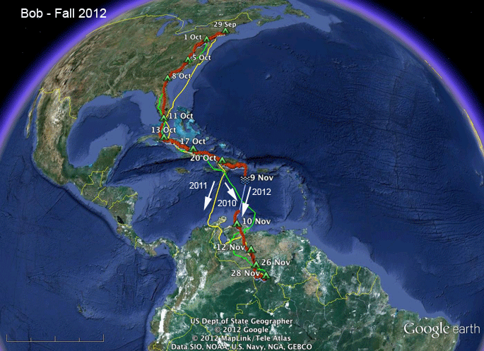 |
29 Sep - 28 Nov 2012.
Bob is is back in his winter hideout
in the highlands of southern Venezuela. He has shown us
once again that Ospreys don't really care what
route they take south, they just need to be
heading in the correct general direction. They sort out the navigation stuff at the
other end. His two previous fall trips are indicated on the map in green (2010) and yellow (2011). He's took 59 days to get back to his winter home--3 more than last year. He does dawdle along the way. Scroll down for all his maps this year, or... Skip to the start of fall migration Skip to the wintering grounds |
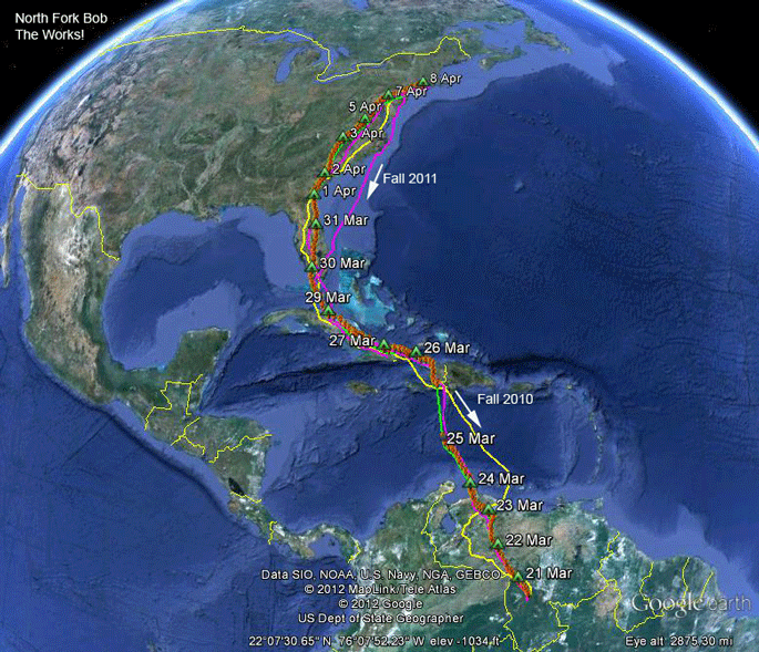 |
21 Mar-3 June 2012. Bob is home after 19 days on the wing. This map shows all his tracks since we tagged him way back in the spring of 2010. The yellow track is his route south in 2010. The hot pink tracks are fall and spring of 2011. Green is this year. |
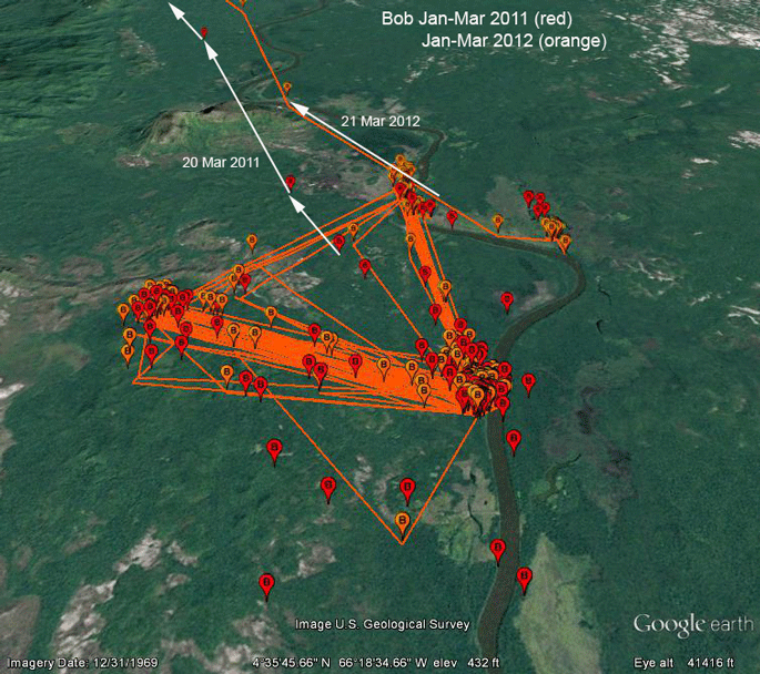 |
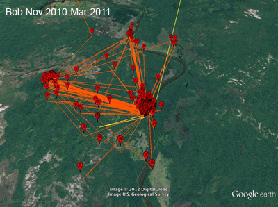
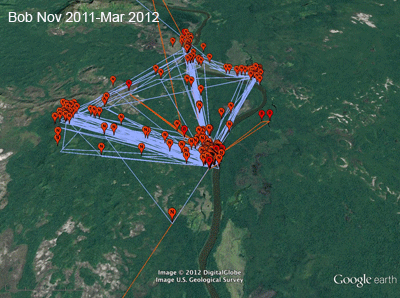
Jan-Mar 2011 vs. 2012. In case anyone needed proof that adults return to the same wintering areas each year, here it is. The red symbols are locations from last winter. Orange symbols and tracks are 2012. He left one day later this year than last. |
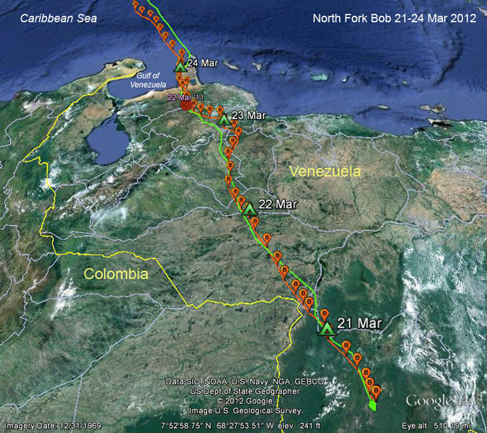 |
21-24 Mar 2012. Bob is a creature of habit. The green track is his route home last spring. The red symbol just south of the Gulf of Venezuela was his roost on 22 Mar 2011. At this point he's about a day and a half behind last year's trip. |
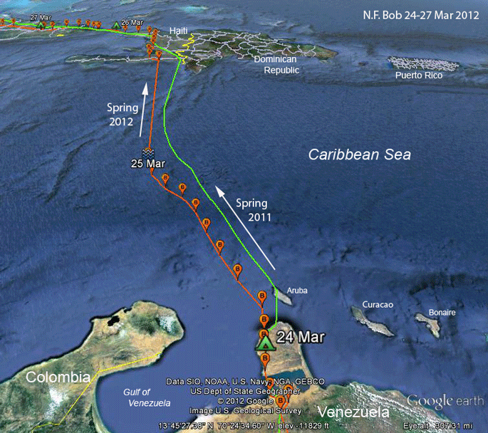 |
24-27 Mar 2012.
Bob followed the standard rule of
avian migration--stay over land as long as
possible. This makes north-pointing peninsulas
great places to watch spring migration and
south-pointing capes (like Cape May, NJ) great
in the fall. This year Bob skipped the visit to
Aruba. He left Venezuela around 9 AM on the 25th. For the next eight hours where we have locations over the water, he flew 213 miles in 8 hours, averaging 27 mph. If he kept that pace up, he would have arrived in Haiti 8.5 hours later--about 2 AM. |
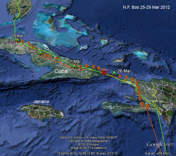 |
25-29 Mar 2012.
Bob spent the night of the 25th on the
south shore of Haiti (I forgot to put his little
tent there) and then pushed north, leaving
around 9AM, pretty much standard operating
procedure. At 5PM he was heading north and ran
out of land, so he pushed out over the short (55
mi) span of open water separating Hispaniola and
Cuba. His last transmission for the day was
where I have the tent on the 26th. He didn't
spend the night there, but rather somewhere on
the eastern tip of Cuba. The red symbol was his roost on the 25th of March in 2011, so he's now exactly 1 day behind last year. He moved north through Cuba, fortunately dodging all the tempting but dangerous fish farms along the way. As of the 29th, he's gone 1,722 mi (2,772 km) in 9 days. |
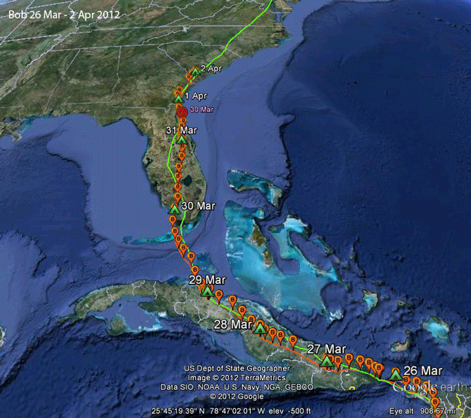 |
29 Mar-2 Apr 2012.
The way we like 'em. No drama, just
pushing north, heading back to Long Island. He's staying on script from last year (the green track) and a day and a half (all of Florida) behind his 2011 pace. |
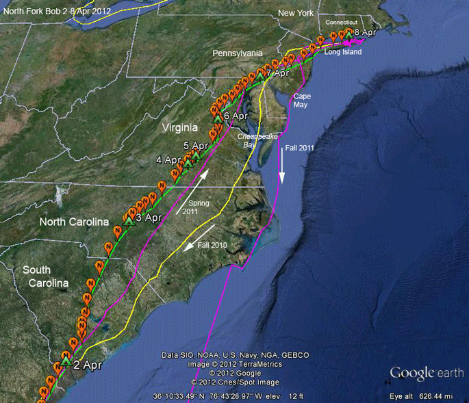 |
2-8 Apr 2012.
The "same old same old" here. Bit of
slow going on the 5th--probably weather related.
Other than that, he was just grinding his way
home. On the last 2 days, he flew 337 miles (543
km)--131 mi (211 km) on the 7th and 206 mi (332
km) on the 8th. On the 7th he roosted somewhere south of Philadelphia, not very far from my new nest. |
 |
8-11 Apr 2012.
OK, let me
walk you through the interpretation of the new
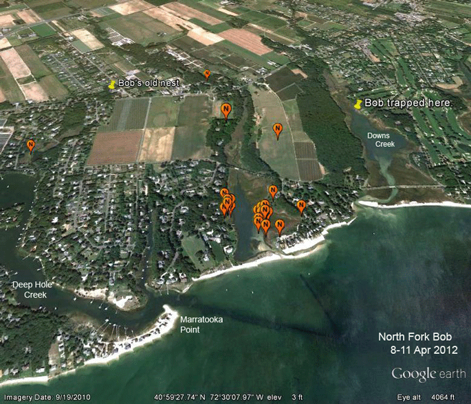
data for North Fork Bob. Very cool stuff! So, here's the first few days' data back around where we trapped him. As some of you will remember but newcomers won't know, we trapped Bob by accident back in the summer of 2010. We were trying to catch a juvenile at a nest just off the Mattituck Golf Club course. We put fish in the nest (a nice bronzino, rather than the usual menhaden--it's a long story) with a noose carpet over the fish. We were expecting the juvenile to come in for a meal, but it was skittish after we'd been up in the nest, so it was hanging back. We caught an adult male, which I assumed was the male at this nest. Turned out it was a larcenous neighbor that saw the fish in the nest and figured that if no one else wanted it, he'd have to take advantage. He got a satellite transmitter instead. We later learned that he had had a nest on a cell-phone tower nearby, but it had been knocked down by a maintenance crew working on the tower earlier that spring. He didn't nest that year, flew to Venezuela and returned the next spring. He didn't nest in 2011 either. So here he is back in the spring of 2012. He didn't go back to his old nest, nor the nest where we trapped him. But he is spending a lot of time around a small pond between Downs and Deep Hole Creeks (Halls Creek, I believe). Let's see why. |
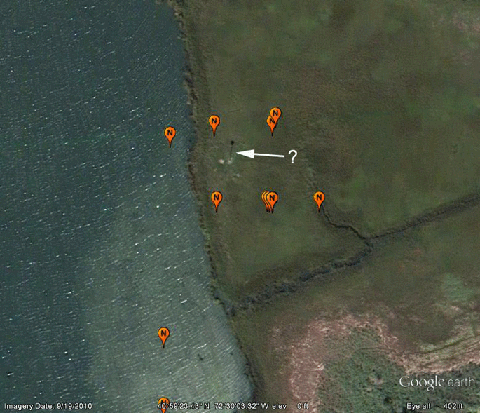 |
8-11 Apr 2012. There's a significant cluster of points here on the east side of the pond. Everyone else on the planet besides me and a handful of Osprey biologists who work a lot with Google Earth would not notice that black lollipop looking thing out in the marsh. What is it? |
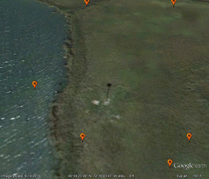 |
It's the
shadow of a nest platform! In this image, one
can actually see the platform. So it looks like Bob has found a home. The question now is will he find a girlfriend as well? OK, all you North-Forkians need to get out there with your binoculars and spend some time watching the nest to see what's going on. This is really cool! When I looked back at the data for the summer of 2011, it turns out Bob spent a lot of time here--(scroll down). |
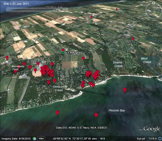 |
Here are his
locations from July 2011 for his core area (more
distant locations from fishing trips aren't
included). He spent a lot of time hanging around
the pond where he is now. I never thought to
zoom in and look very closely at this spot, or I
would have noticed the nest pole. This is how young Ospreys find a nest in their first few years back in their natal areas. We call them "house hunters." They're not quite ready to breed, or perhaps are ready to breed, but there aren't any unoccupied territories available. Sometimes they float around building nests on any old structure they can find--often winding up in trouble in the process when the structure they choose is a power transformer or some other inconvenient nesting spot like cranes or sailboat masts. But sometimes they get lucky and find an unoccupied prime real estate nest site on a salt marsh like this. If they can hold on to the spot over the course of the summer, they get a sense of ownership, and when they come back the next spring, they're going to have enough of an attachment to the location that they're likely to run off any other pretenders to their throne--the home-court advantage is huge in birds. True veterans of these maps will remember that some of our first adults tagged way back in 2000 and 2001 left Martha's Vineyard after their nests failed and then began commuting between some fresh-water fishing hole in NE CT and their territories back on the Vineyard. Why go to all that trouble? Because you don't want some young whippersnapper like Bob to get any ideas about taking over your nest pole! They basically fly all that way to keep the No Trespassing signs up around their home turf. (keep scrolling) |
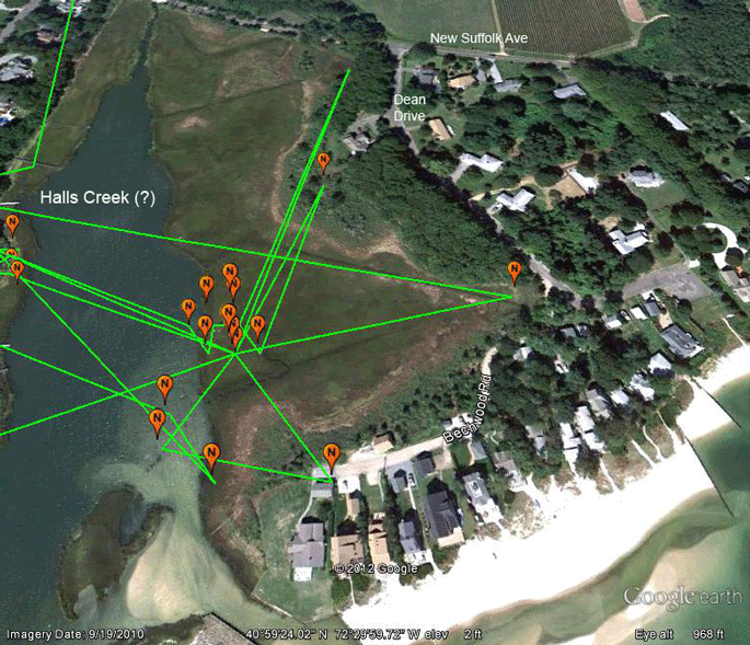 |
So, grab your
spotting scopes and binoculars and head out New
Suffolk Ave to Dean Drive. Go down Dean Dr. to
Bechwood Rd. At the end of the road, there looks
to be a good view of the nest. Report back any
and all intelligence to Osprey HQ! Specifically, we want to know, obviously, does he now have a mate? Are there more than 2 birds around the nest? Sometimes early in the spring there can be several contenders (of either or both sexes) vying for the vacancy. These struggles can often be noisy protracted affairs. Sometimes it's such a drawn out battle that the birds never get around to nesting. What happened last year? Was he hanging out alone or were there 2 birds around the nest in July and August? Local residents may know. (We may need to wait until later in the summer to find this out.) If Bob does find a mate and gets a nest going, it will be our chance to re-trap him and relieve him of the transmitter he's been kindly lugging back and forth between Long Island and Venezuela. There's no need for him to do it again, so we'd like to move that transmitter to another bird. |
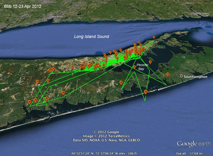 |
12-23 Apr 2012. Apparently run off the nest where he was trying to stake a claim, Bob's been all over eastern Long Island. He's obviously given up on nesting this year. |
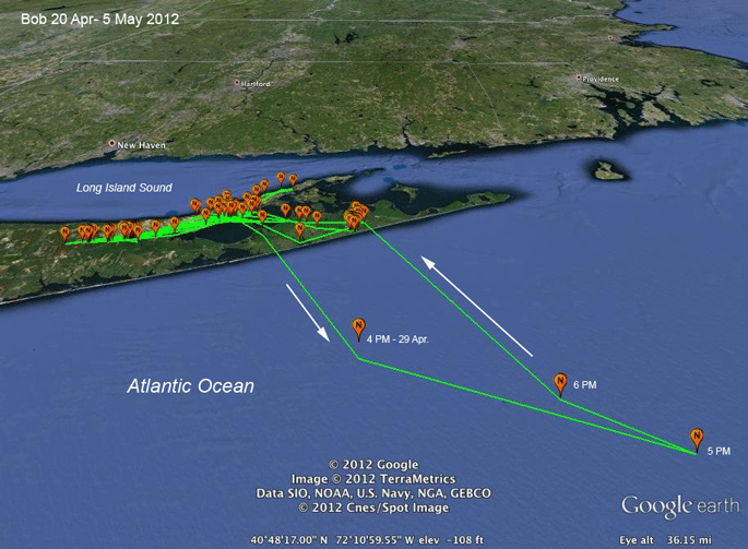 |
20 Apr-5 May 2012. Bob was feeling a bit adventurous on the 29th. He headed out over the open Atlantic around 3:30 PM on the 29th. Our farthest fix was 42 miles (68 km) offshore. He could have been further out, as we really don't know where he went between 5 and 6 PM. Remember that the lines between points don't mean that this was the path he took. They just serve to let us put the points in chronological order. He was certainly wandering around somewhere out there between 5 and 6 PM. This is the first time he's been out deep-sea fishing! (Our Nantucket bird, Sr. Bones, has done a bit of this, but it's the first time for Bob.) |
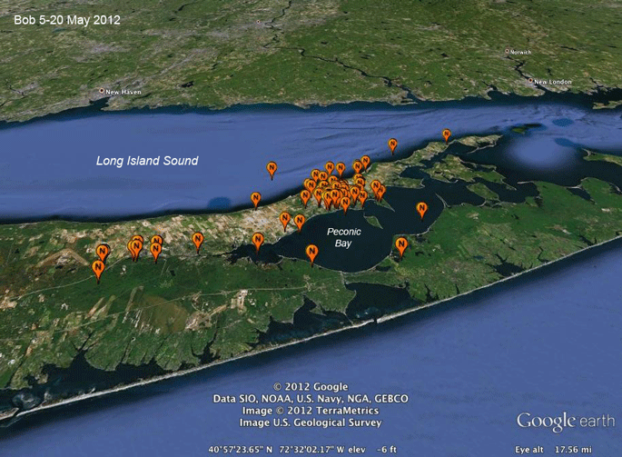 |
5-20 May 2012. Not much going on here. Just a carefree bachelor wandering around looking for some easy fishing. |
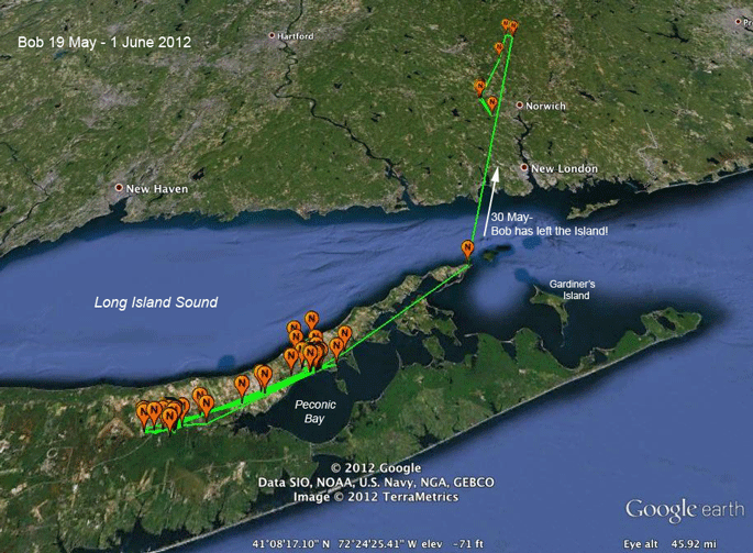 |
19 May - 1 June 2012.
Well, that was
unexpected! Bob's on a road trip over to
Connecticut. This suggests that the fishing's
not very good this year. We've seen several female Ospreys from Martha's Vineyard commute to and from northeastern Connecticut after their nests failed. We also had an adult from Shelter Island commute to and from CT, presumably after a nest failure. When the fishing's bad in the salt water ecosystem, Ospreys head to freshwater fishing holes. |
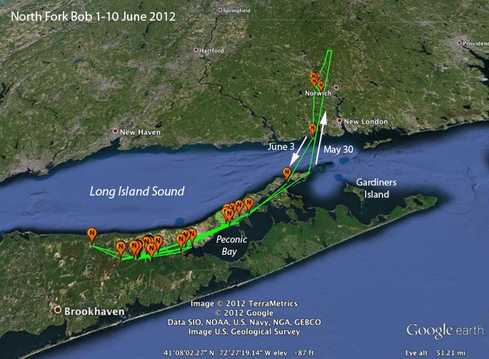 |
1-10 June 2012. Bob's back on Long Island. He's spending most of his time on the Peconic River, west of Peconic Bay. |
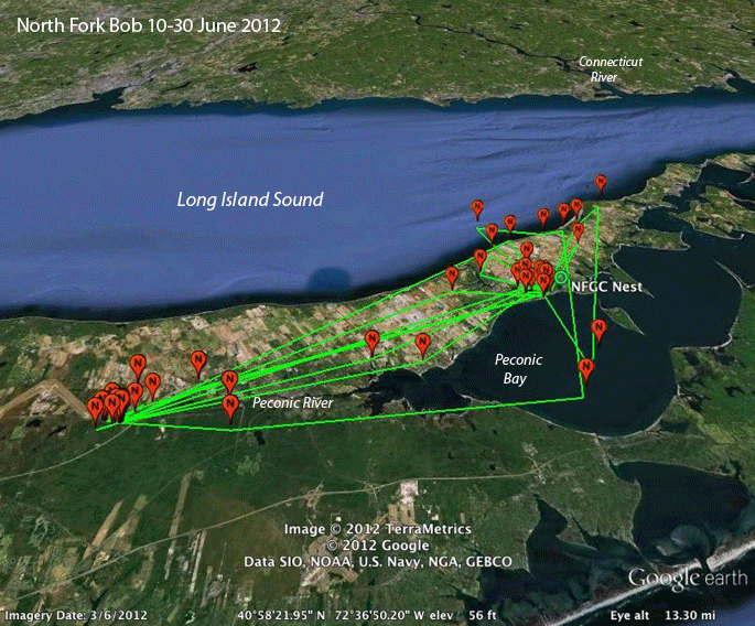 |
10-30 June 2012.
Bob's bouncing
back and forth between his fishing hole on the
Peconic River near the Calverton Airport (see
picture below) and the Mattituck area, where he
tried to steal a fish from a nest that just
happened to have a noose carpet on it a couple
of years ago. We see here that he's hunting out in Peconic Bay as well as out in Long Island Sound. |
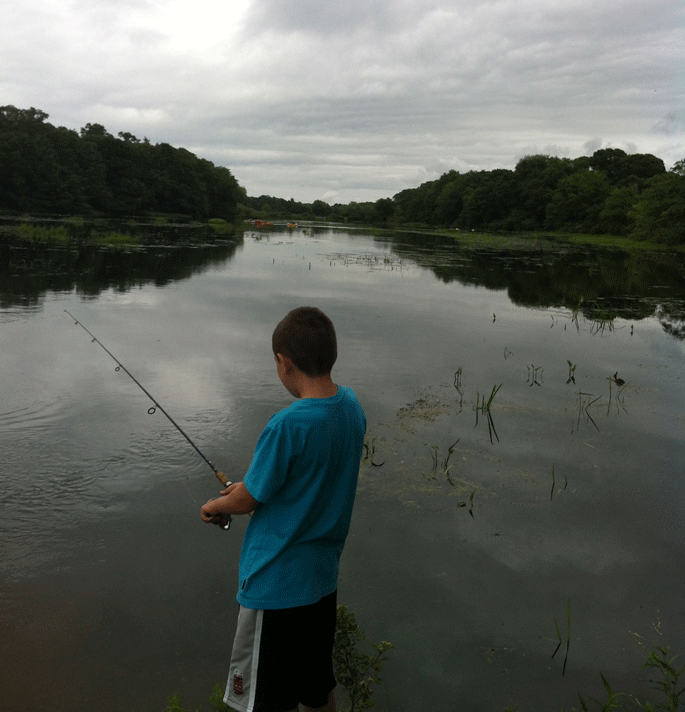 |
On my way up to Mattituck to trap this year's Long Island Osprey, I stopped by North Fork Bob's favorite fishing spot on the Peconic River. It's a rather idyllic little stretch of the river that has been dammed, so it's wide and presumably pretty shallow. An ideal spot for Osprey fishing. Apparently some humans agree. |
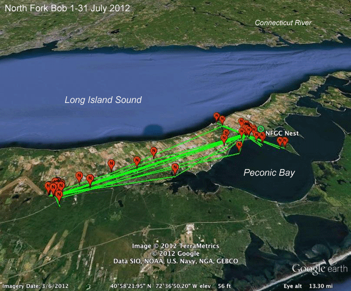 |
1-31 July 2012. Bob's not fishing the Sound, but is working the north part of Peconic Bay near Mattituck--when he leaves his Peconic River hideaway. |
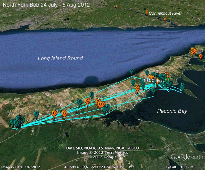 |
24 July - 4 Aug 2012. Here's the last 10 days' data showing some overlap with our newly trapped non-breeding adult male, Cutch, who was caught dipping his talons in the same cookie jar (nest) that we caught Bob in 2 years before. |
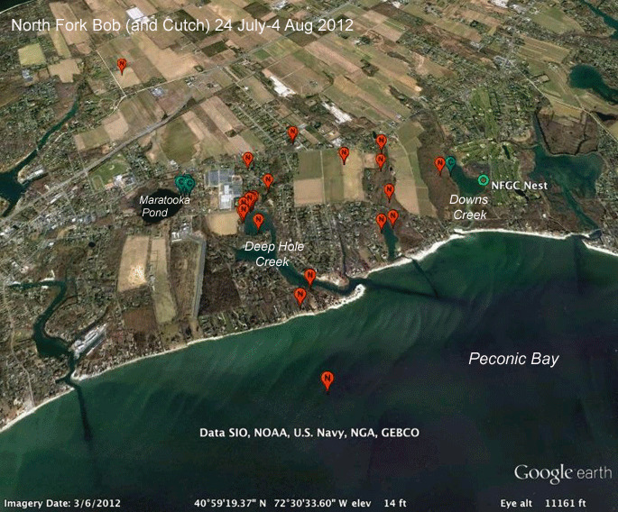 |
24 July - 4 Aug 2012. Bob and Cutch may have bumped into each other in the Mattituck area. |
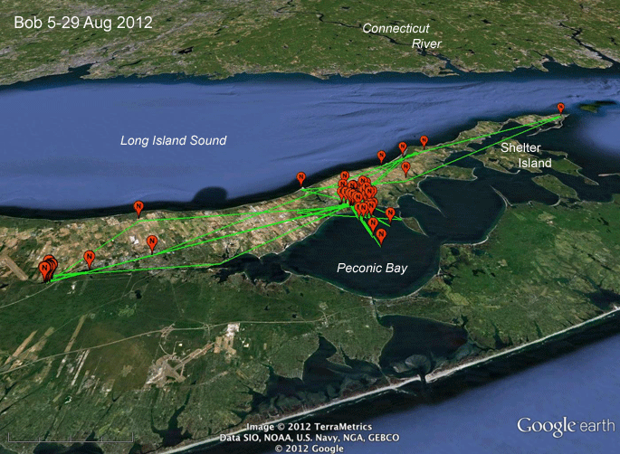 |
5-29 Aug 2012. Bob made a couple of trips west to his fishing hole on the Peconic River in Calverton. He also made a quick trip out to Orient Point, about 30 miles east of the Calverton spot. Most of his the month was spent around Mattituck, close to where we trapped him. |
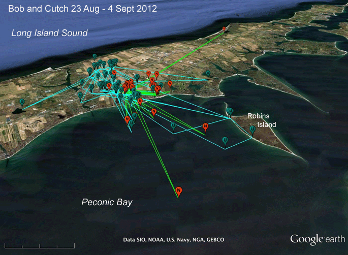 |
23 Aug-4 Sept 2012.
Bob spent
almost all these 15 days around Mattituck. I've
also included Cutch's locations for the same
time frame. Both Bob and Cutch did some fishing out in Peconic Bay. |
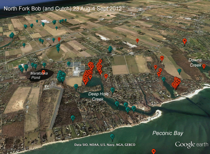 |
23 Aug-4 Sept 2012.
These seem to
be easy days for our boys Bob and Cutch. They're
spending a lot of time just hanging out. It
looks like they're catching a fish in Peconic
Bay and then just chillin' around a few favorite
hang-outs. What's particularly interesting here is that Bob is going back to the marsh between Deep Hole Creek and Downs Creek (it doesn't have a name on the USGS Topo maps) where he tried to claim the nest pole this spring. |
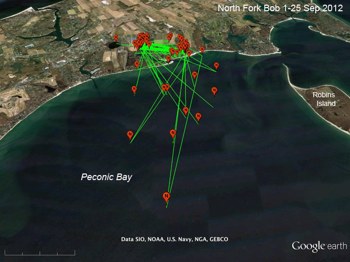 |
4-25 Sept 2012.
OK, Long
Islanders, what's Bob catching out in the Bay?
He's doing a lot of fishing way off shore. Are
there a lot of menhaden out there? His fellow homeless Osprey, Cutch, took off for points south on the 10th. Bob is one of only 2 of our 10 tagged birds in North America that aren't migrating yet. But he was late last year as well, leaving on 3 October, so he seems to be on his regular schedule. He's also still hanging around the nest he tried to occupy last spring. Maybe he'll have better luck next year. |
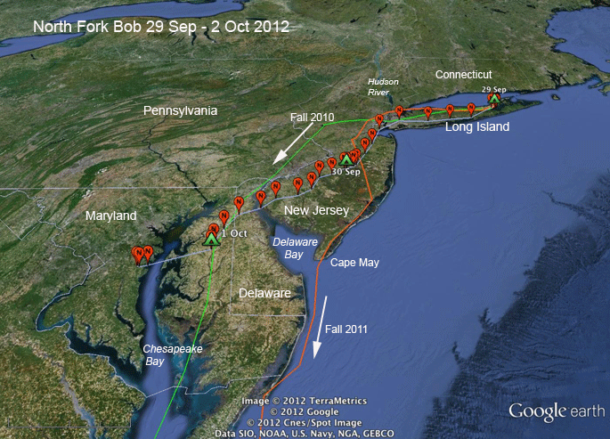 |
29 Sept-2 Oct 2012. This year Bob started his fall migration on the 30th. Last year he started on the 3rd of October, and in 2010, the first year we tracked him, he started on the 19th of September. This is the first year we've seem him go down the west side of Chesapeake Bay. |
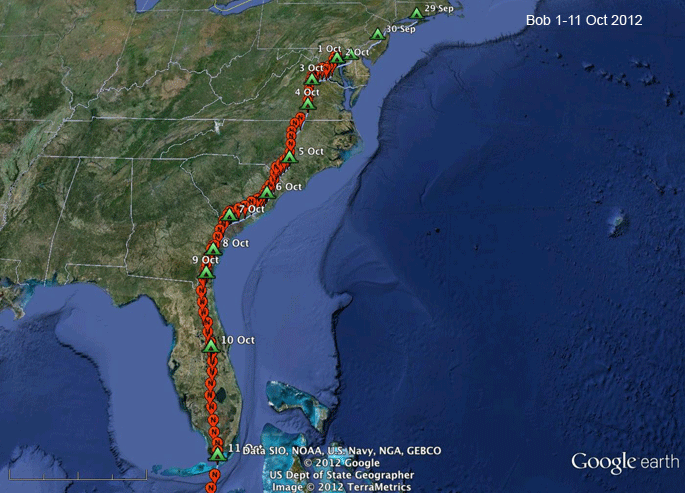 |
1-11 Oct. 2012. Bob is taking care of business--moving south every day since he left Long Island. |
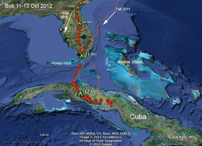 |
11-13 Oct 2012. Here we can see how south-facing peninsulas funnel birds to concentration areas. In Bob's case, the funneling happened over the three fall migrations we have tracked him. That's why Cape May is such a great hawk watching spot and why the Florida Keys Hawk watch counted an astounding 651 Peregrine Falcons on October 10th! |
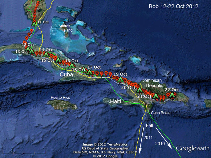 |
12-22 Oct 2012.
Bob just
cruised through Cuba and made it over into the
D.R. on the 21st. He missed the turn south to
Cabo Beata most likely because Hurricane Sandy
was raging up the Caribbean (see the next map).
He made me very nervous by settling down in the D.R for almost three weeks. |
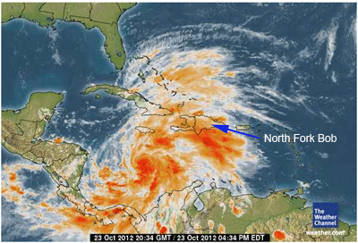 |
22 Oct 2012. Bob dodged a bullet by being on Hispaniola rather than half way to Venezuela when Sandy barreled west through the Caribbean. |
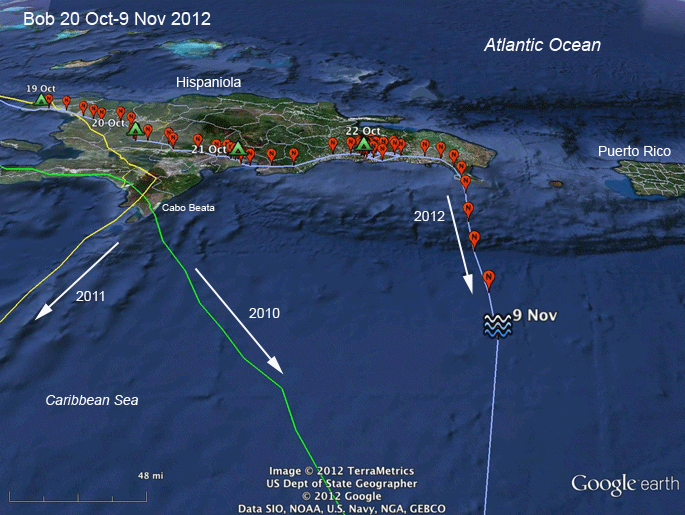 |
22 Oct-9 Nov 2012. Bob left his temporary bivouac around 11AM on the 9th. As he moved east, he wasn't in full migration mode. Some of his hourly fixes were only 10 miles or so apart. That means he wasn't in straight flapping mode, but was either using thermals or stopping along the way for a bit of fishing. By 4PM he was moving south full speed ahead--which is about 25mph under normal conditions. |
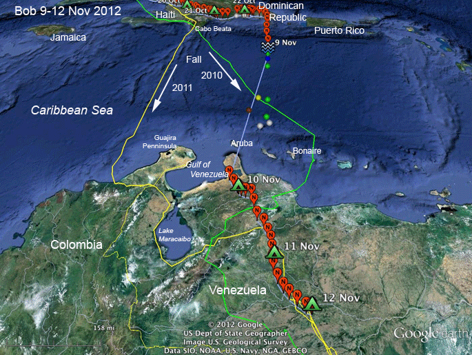 |
9-12 Nov 2012.
Bob made the
crossing apparently without a hitch. The colored
balls mark where he was (roughly) when he was
sending his GPS data up to the satellite. He did
this at night while he GPS unit was not
collecting data. These locations are the old
"Doppler" fixes that we used to rely on before
GPS capability was added to the transmitters.
They're not precise, but they do tell us that
his path to South America did not follow the
straight line that connects the last GPS fix on
the 9th to the first on the 10th. His whole crossing was probably about 450 miles (817 km) and would have taken around 18 hours. |
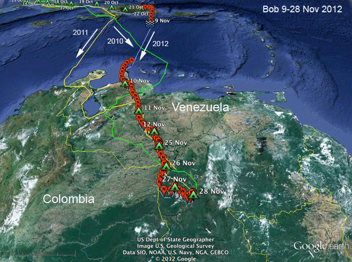 |
9-28 Nov 2012.
Bob spent a
couple of weeks in the llanos of Venezuela
before making the final climb up into the
highlands to get to his winter hideout. The maps below detail these last legs of the trip. |
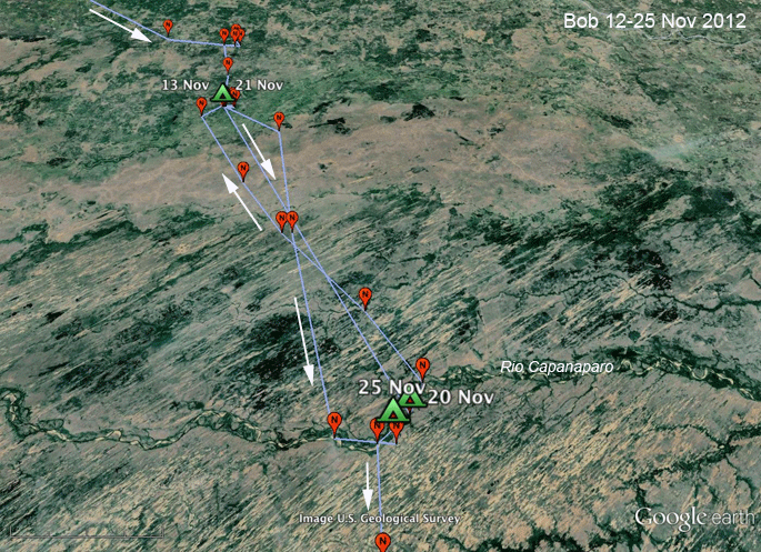 |
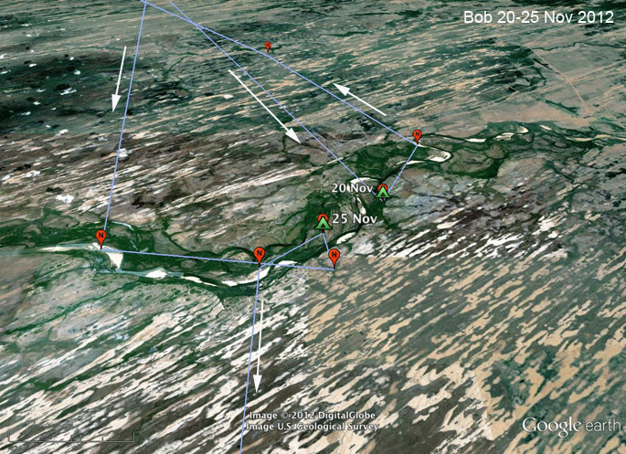
9-12 Nov 2012. For reasons known only to himself, Bob stopped migrating (again!) in the Venezuelan state of Apure beginning on the 13th. On the 20th he flew down to the Rio Capanaparo late in the day, spent the night there, and apparently unimpressed, flew back north. After 4 days back there, he started the final leg of his long trip back to his wintering area on the Rio Ventuari. |
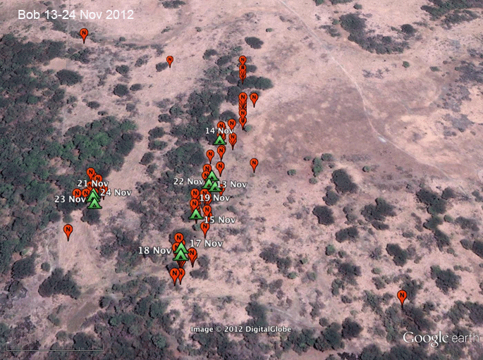 |
9-12 Nov 2012. This looks like a most unlikely spot for an Osprey to spend a couple of weeks, but we have to remember that this part of the Venezuelan llanos is a seasonally flooded wetland. This picture was taken during the dry season. Had this been a current picture, we'd see a lot of water in this area. |
 |
9-12 Nov 2012. Bob spent a couple of nights on this small river in the middle of the bizarre sand dune region of the state of Apure. |
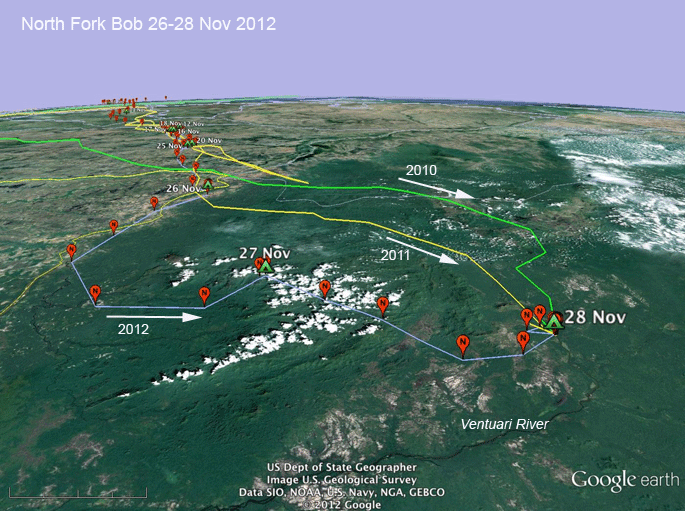 |
9-12 Nov 2012. Bob took yet another route to his favorite winter fishing hole on the Ventuari River this year. This is the third year we've tracked him, and each year he's climbed up onto the Guianan Shield by a different route. |
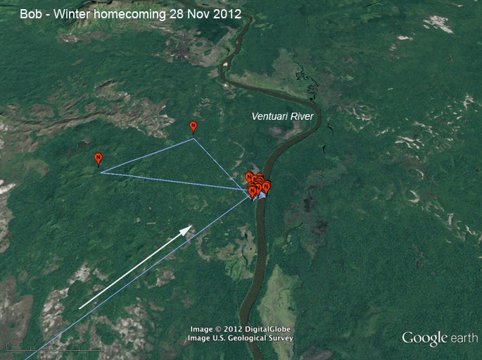 |
9-12 Nov 2012. Home, sweet home! |
 |
 |
|
| These maps show all of Bob's GPS locations for the two winters we have tracked him. He used an area of about 35 square miles (92 km^2) over the 5 months he spent down there each winter. | ||
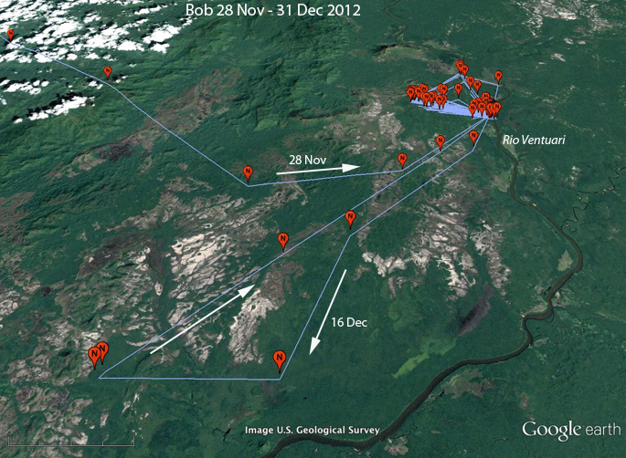 |
28 Nov-31 Dec 2012. Wow! Where'd that come from? Bob took off on a one-day, 70 mile (110 km) road trip. That's the first time he's left the general area along the Rio Ventuari in two and a half winters. I wonder what triggered that. |
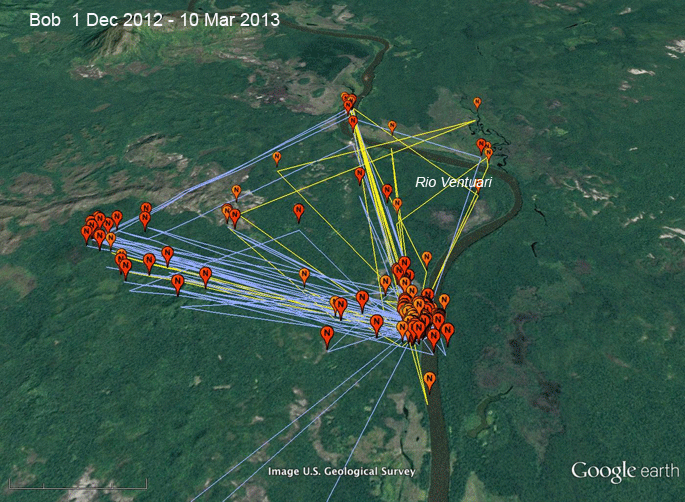 |
1 Dec 2012 - 10 Mar 2013. Now he's back to his regular pattern of habitat use. He has 3 main areas where he likes to fish. The brighter orange balloons are his locations in December. From January on, his locations are the lighter orange connected by yellow paths. Most of his time over nine weeks after New Year's was spent right alongside the river. |
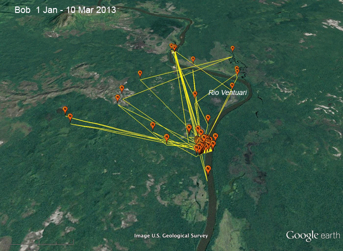 |
1 Dec 2012 - 10 Mar 2013. These are just the locations from Jan 1st through March 10th. |
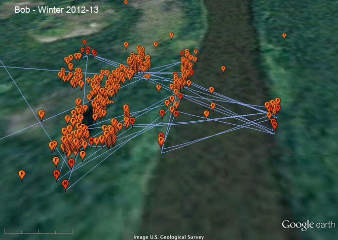 |
1 Dec 2012 - 10 Mar 2013. Here's a close-up of his activity. The resolution's pretty bad. The dark strip running up and down the image is the Rio Ventuari. He does hang out along the river some, but most of his activity is along a small lake just beside the river. He obviously has some perches he likes--where you can see the balloons stacked up. |