Jill - 2012
'09 maps for:
Bea
--
Buck -- Caley --
Claws --
Conomo --
Hix --
Hudson 09 -- Isabel --
Katy -- L.R. --
Moffet --
Mr. Hannah --
Ozzie --
Penelope
--
Rafael
2010 maps for: Belle
-- Buck --
Gunny --
Hudson --
Mr. Hannah --
Neale --
North Fork Bob
--
Penelope --
Sanford
-- Sr. Bones --
Thatch
2011 maps:
Belle --
Buck --
Henrietta --
Katbird
-- North Fork Bob --
Pemi --
Saco --
Sanford --
Sr. Bones --
Snowy --
Thatch -- Tucker
2012 maps: Art -- Belle -- Bridger --
Chip -- Cutch --
Jill -- North Fork Bob --
Rammie -- Snowy --
Sr. Bones -- Thatch
2013 maps: Art --
Belle --
Bridger --
North Fork Bob --
Rammie --
Snowy --
Sr. Bones
Osprey
main page --
Migration
page --
Migration09 --
Migration10 --
Migration 11 --
Migration 12 --
Migration 13 -- Home
Page
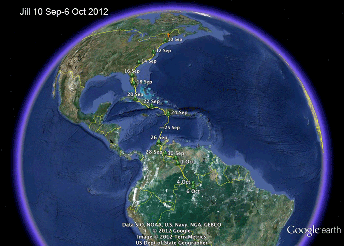 |
10-30 Sep 2012 -
Jill's little brother Chip got a head start on
her, leaving the nest on 21 Aug, but he got
distracted in Rhode Island (where he still is!). Once she decided to
go, it was full speed ahead, and she led our whole flock of 10
migrating Ospreys all the way to South America.
Sadly, she stopped moving in the Brazilian rainforest, just 50 miles east of Pico de Neblina, the highest point in the massive Guianan Shield, which forms the northern rim of the Amazon Basin. Scroll down to see all her maps, or... Skip ahead to the start of migration. |
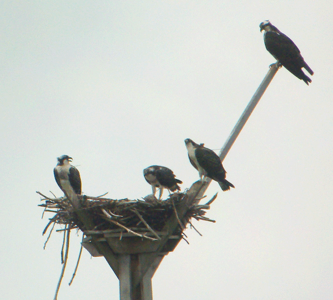 |
4 Aug 2012 - Chip is on the right, Jill on the left (you can see their antennas if you look really closely). Their sister is enjoying a meal while Mom looks on from the nest perch. Iain MacLeod, my co-conspirator on the New Hampshire Osprey research, took this picture just holding his cell phone up to his spotting scope. Pretty nifty work! |
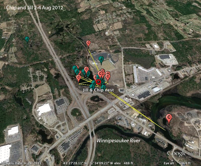 |
2-4 August 2012 - Chip and Jill have only been on the wing for a week or so and are sticking pretty close to home. |
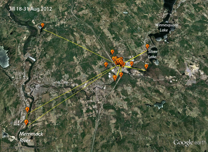 |
18-31 August 2012 - Jill is beginning to explore a bit, but still pretty much hanging around her nest. At this point Mom has almost certainly left for points south. Dad will still be there, bringing home fish and wishing that Jill would follow Chip's lead and head south. |
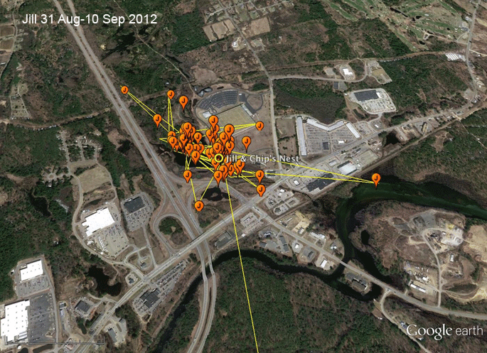 |
1 Aug-10 Sep 2012 - Other than those two short forays away from the nest, Jill pretty much stayed in her front yard, probably never out of sight of her nest, for the whole 10 days here. Saco, a young female tagged last year, did the same thing. That bird was never more than 500 yds from her nest until the day before she started migrating. |
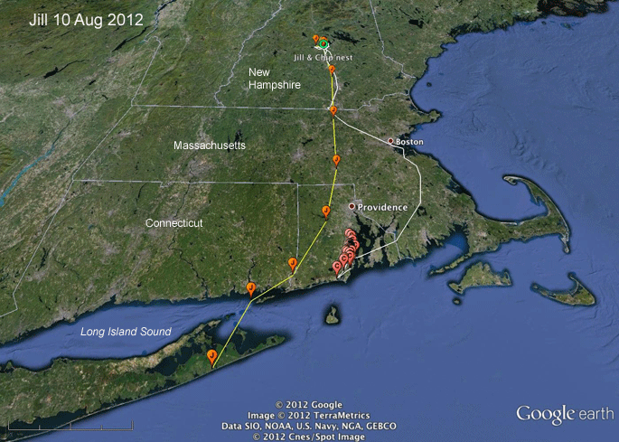 |
10 Aug 2012 -
Jill left home about 9AM on the 10th and, with a
strong tail wind, averaged over 30 mph for the
first 3 hours on the wing. I've included the
path and locations for her little brother Chip
in this map. Chip is having too much fun
catching fish in the Pettaquamscutt River to
think about migrating. She kept moving for about 2 more hours after the last location here and settled for the night near Eastport, near Long Island's south shore. |
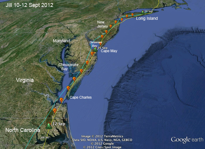 |
10-12 Aug 2012 -
Jill was probably counted at the hawk migration
watch at Cape May late in the afternoon of the
11th. She kept moving right on down the coast,
as if she'd been doing this for years. In fact, she doesn't have any sort of map in her brain, she's just following two very simple rules--go south and stay over land if at all possible. The blue track is Cutch's path over the same time period. He also started migration on the 10th. He was trapped as an adult, so he's done this at least once before. |
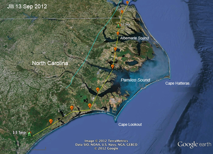 |
13 Sep 2012 - Just cruising along, heading for points unknown. We really have no idea what makes a young Osprey decide it's time to stop migrating and settle down. Sometimes they'll stop for a month and we're sure they've settled down only to see them get started again and migrate thousands of miles further south. |
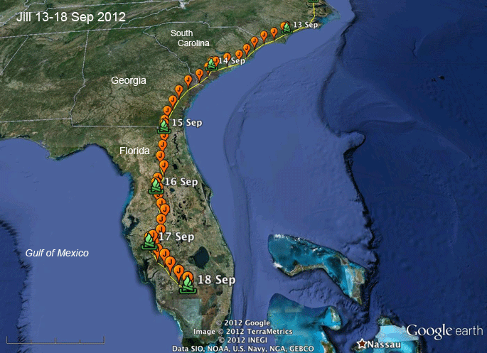 |
13-18 Sep 2012 - There seems to be no stopping Jill. She's had good weather all the way. She's probably a day away from Cuba. And that's when we really get nervous. She has to dodge fish farms in Cuba, farmers in the Dominican Republic that think Ospreys might eat their chickens, and then the Caribbean in the peak of hurricane season. |
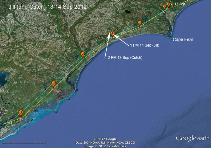 |
13 Sep 2012 - Back tracking a bit here, by a not terribly surprising coincidence, Jill and Cutch (probably a 3-yr old from Long Island) were at the same place just 23 hours apart. We can see that Cutch was flying a bit faster than Jill along the North Carolina coast southwest of Cape Fear. |
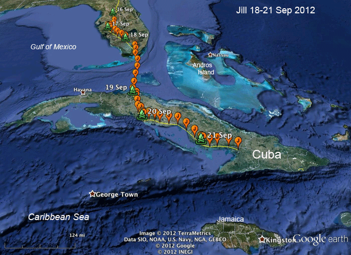 |
18-21 Sep 2012 - Jill hasn't stopped for a day. |
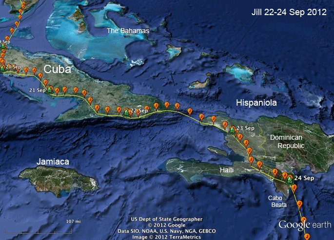 |
22-24 Sep 2012 -
Jill is the Energizer Bunny of Osprey migrants.
She's handling the Cuba-to-Hispaniola route like
she's done it before, unlike a lot of first-year
birds. Some young birds hit the south coast of
Cuba and keep going south, winding up with about
1,000 miles of Caribbean to cross before getting
to Panama. Others, in fact the majority, get to
Hispaniola and keep going east until they run out
of island and then turn south. Not many of them
find the convenient jumping off point at Cabo
Beata, where it's only 350 miles (500 km) to the
nearest land in South America (the Guajira
Peninsula). Her path along Cuba's south coast was also a bit unusual. Most of the birds we've followed through Cuba go down the middle of the Island. Jill is one bird that might have been counted by Freddy Santana's Osprey counters on Gran Piedra, overlooking Guantanamo Bay, AKA Gitmo. |
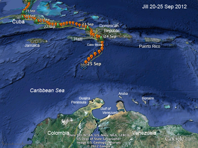 |
20-25 Sep 2012 -
Jill is out over the Caribbean. There was one
big batch of clouds and rain in front of her
when she took off, but I think she's going
around that. By now (the 27th) she should have
made landfall in Colombia somewhere. With data
downloads only every 3 days, we often have
cliff-hangers like this when our birds cross the
Caribbean. At her last roost on Hispaniola, in 15 days of non-stop migration she had traveled 2,499--OK, let's make it an even 2,500--miles, averaging 167 miles/day, (4,021 km; 268 kpd) which is maybe a bit above the norm for birds going overland the whole way. (Birds that cross the Atlantic from Martha's Vineyard have to fly through a couple of nights, so their averages are a lot higher.) |
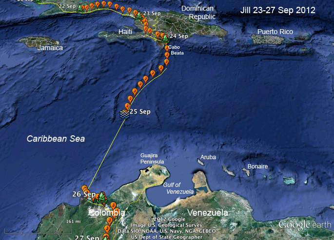 |
20-25 Sep 2012 - Jill made it safely over the Caribbean. She started the day's migration on the 25th around 9:30 AM and traveled 293 miles (473 km) in 11.5 hours, averaging 25.5 mph (41.4 kph) before her GPS shut down (the blue squiggly mark). Overnight, while her GPS unit was napping, she moved 216 miles (348 km). If she kept the day's speed up, the remaining 215 miles (348 km) would have taken her about 8 hours to cover, so she probably arrived on the Colombian coast around 5 AM--about 19 hours after she left the D.R. |
 |
20-25 Sep 2012 -
[Looking south now!] Jill landed in Colombia at
the western end of the Sierra Nevada de Santa
Marta mountains, which tower up to 18,700 ft
(5,700 m) above the Caribbean. No wonder she
followed the mountains (at about 4,100 ft ASL (1,230 m)until she found a
relatively low pass down into the Valley
to the east.
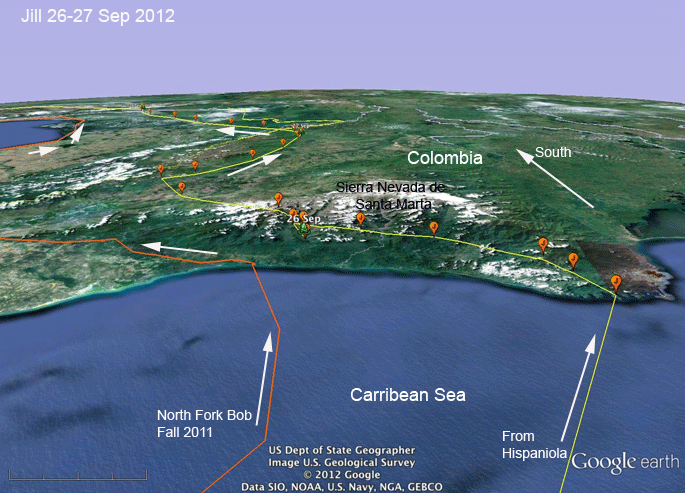
North Fork Bob did basically the same thing last year, although he didn't get nearly as far up into the mountains as our girl Jill did. Maybe it's because he's from Long Island and Jill's from the White Mountain state. |
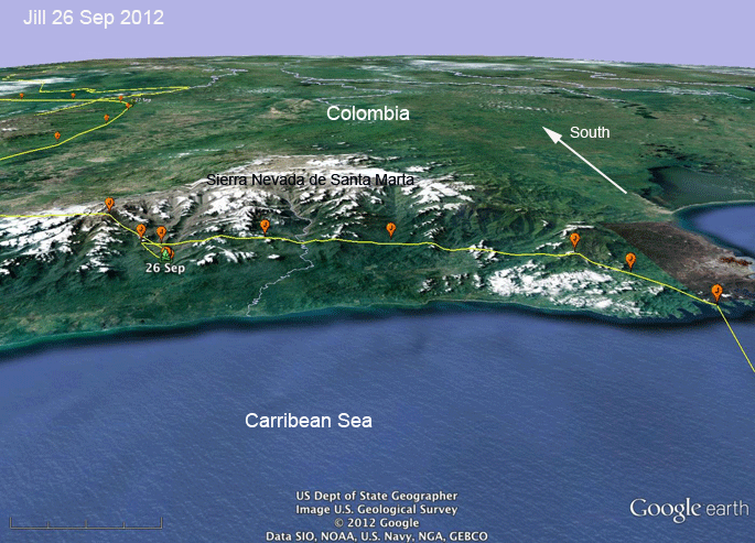 |
20-25 Sep 2012 -
[Still looking south]
Jill finally crossed the mountains at a pretty
high altitude. The highest point we have for her
was 4.034 ft (1,230 m). When she decided to quit for the day on the 26th, she dropped down slope a bit to roost. The next morning, it was up and at 'em, crossing the mountains about... |
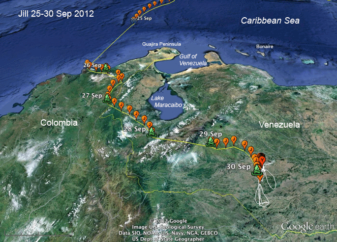 |
25-30 Sep 2012 -
(Looking north again--you can turn your computer
right-side up now.) Jill has crossed three--
count 'em--mountain ranges. First was the Sierra
Nevada de Santa Marta. Then she was down in
valley between the Sierra Nevada and the
Cordillera Central, and then over that range
into the Tachira Depression, and finally over
the Cordillera Oriental (eastern) into the
llanos of Venezuela. Sometime in the afternoon of the 30th, she passed about 10 miles west of Snowy's winter turf. Snowy is a 2011 juvenile from Martha's Vineyard doing his "gap year" in South America. The red/Y balloons are Snowy's locations for the past 10 days or so. The white tracks are places Snowy has been over the past year. |
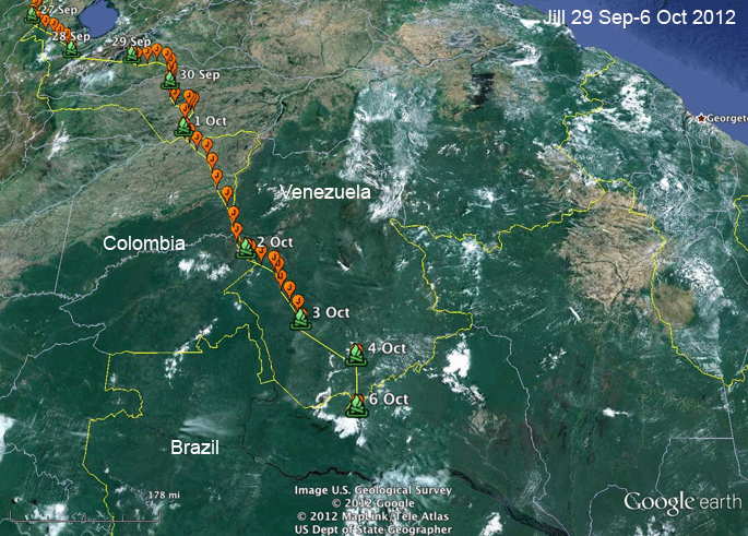 |
1-6 Oct 2012 -
Jill was cruising right along like she knew what
she was doing. She had been in full migration
mode every day since she left her natal area 16
days before these last locations. Her transmitter went a bit funky on us after the 3rd. No locations during the day of the 4th--just a location at the end of the day, and then nothing at all on the 5th, and locations but no movement on the 6th. |
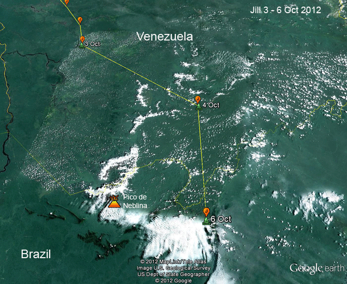 |
3-6 Oct 2012 - Jill's locations for the 6th were all in a very restricted area about 50 miles east of Pico de Neblina ("Foggy Mountain"). Her transmitter was not working well in the few days before her last transmission. We have only 1 point for the 4th and none for the 5th. Incurable optimists (of which I often count myself) can hope that Jill didn't die here, but is just carrying a bad transmitter. |
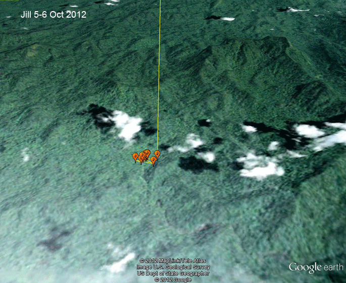 |
5-6 Oct 2012 - This appears to be the end of the line for Jill in the rugged Guianan highlands just east of Pico de Neblina. |