Links: Previous
map for Della -- Next map for Della
'06 Maps for: Conanicus -- Della --
Erica -- Homer -- Jaws
-- Lew --
Moshup
Birds
of Prey page -- Osprey
main page -- Migration
page -- Home
Page
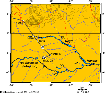 |
24 Oct: This looks
like it might be the end of the road for this migration. (Of course now
she'll fly 300 miles south!) On the 17th she pushed south through the
Brazilian Amazon between the Rios Negro and Solimoes (which is what the
Amazon is called in Brazil upstream of the confluence of the Negro and
"Amazonas.") She spent some time on the 17th at the headwaters of
a tributary of the Negro and then moved further southwest and spent a day
and a half pretty much in the middle of nowhere. On the 20th she found a
small lake that appears to be to her liking. The Ospreyometer clicked over 4000 mi to 4091 (6,550 km). In 44 days since leaving her nest area in Delaware, she's averaged 93 mi/day (149 km/day), which is pretty close to the norm. (Scroll down for a Google Earth image). |
|
|
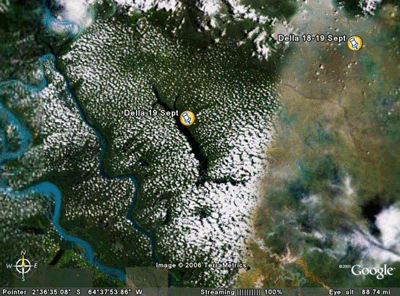
Here's a Google Earth image of two of Della's
locations as she moved through Amazonian Brazil. You can see the mosaic nature of Google Earth here. This image is a composite of two pictures taken on different days, with different weather on the two days. In the left portion of the picture you can see the lake where she's been for the past 5 days or so. You can also notice clouds just over the forest--At least half the rain that falls on the rainforest is the result of moisture rising up out of the forest nearby. In the lower left of the image, the Rio Solimoes (Amazonas) can be seen. The river is not blue, but rather a silt-laden cafe au lait color. It's blue in this image as a result of manipulations to the image beamed down from the satellite. |
|
|
Birds of Prey page -- Osprey main page -- Migration page -- Home Page